Back Индиън Ривър (Флорида) Bulgarian Indian River (Florida) German Indian River (Floride) French Indian (fiume Florida) Italian ഇന്ത്യൻ റിവർ Malayalam Індіан (річка) Ukrainian
| Indian River | |
|---|---|
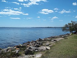
 Indian River at Melbourne | |
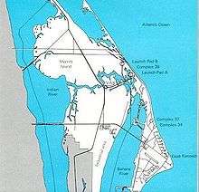
 NASA map showing Indian River on left | |
| Location | |
| Country | United States |
| State | Florida |
| Physical characteristics | |
| Source | |
| • location | Ponce de Leon inlet |
| • elevation | 0 ft (0 m) |
| Mouth | |
• location | St. Lucie Inlet |
• coordinates | 27°50′N 80°27′W / 27.83°N 80.45°W |
• elevation | 0 ft (0 m) |
| Length | 121 mi (195 km) |
The Indian River is a 121-mile (195 km) long[1] brackish lagoon in Florida.[2] It is part of the Indian River Lagoon system, which in turn forms part of the Atlantic Intracoastal Waterway. It was originally named Rio de Ais after the Ais Indian tribe, who lived along the east coast of Florida, but was later given its current name.
The Indian River extends southward from the Ponce de Leon inlet in New Smyrna Beach in Volusia County southward and across the Haulover Canal and along the western shore of Merritt Island. The Banana River flows into the Indian River on the island's south side. The Indian River continues southward to St. Lucie Inlet.[3] At certain seasons of the year, bridges have tended to impede the flow of gracilaria (a red algae), resulting in an odor of hydrogen sulfide in the area.[4]
- ^ U.S. Geological Survey 7½ minute topographic maps
- ^ Long, Doug (13 March 2010). "Column:Help!". Florida Today. Melbourne, Florida. p. 4D.
- ^ "Description of the Indian River Lagoon - Appendix B" (PDF). Archived from the original (PDF) on 2013-10-02. Retrieved 2013-09-26.
- ^ Waymer, Jim (2 July 2010). "Man on mission to sweeten smell of Indian River Lagoon". Florida Today. Gannet. Archived from the original on 7 April 2015.
© MMXXIII Rich X Search. We shall prevail. All rights reserved. Rich X Search