| Indiana Central Canal | |
|---|---|
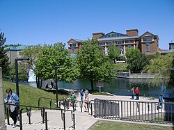
 The canal in downtown Indianapolis | |
 Map showing the Central Canal and other projects of the Indiana Mammoth Internal Improvement Act | |
| Location | Indiana |
| Country | US |
| Coordinates | 39°46′15.3″N 86°09′54.75″W / 39.770917°N 86.1652083°W |
| Specifications | |
| Length | 8 miles (13 km) (originally 296 mi or 476 km) |
| Status | Partially built |
| History | |
| Construction began | 1836 |
| Date restored | 1985 |
| Geography | |
| Start point | White River at Broad Ripple (originally Wabash River at Peru, Indiana) |
| End point | White River at downtown Indianapolis (originally Ohio River at Evansville, Indiana) |
The Indiana Central Canal was a canal intended to connect the Wabash and Erie Canal to the Ohio River. It was funded by the Mammoth Internal Improvement Act, Indiana's attempt to take part in the canal-building craze started by the Erie Canal. $3.5 million was allocated for the project, the largest piece of the entire $10 million Act. However, due to the Panic of 1837, Indiana suffered financial difficulties and had to turn the canal over to the state's creditors, and building of the canal was stopped in 1839.[1] The canal was supposed to extend 296 miles (476 km), from Peru, Indiana, to Evansville, Indiana, where it would reach the Ohio River. It was originally divided into two sections, North and South. Later, a third section was designated, called the Indianapolis section. Only eight miles (13 km) were completed, with an additional 80 miles (130 km) between Anderson, Indiana, and Martinsville, Indiana, having been partially built.
- ^ Dunn, Jacob Piatt (1919). Indiana and Indianans. Chicago: American Historical Society. p. 415.
© MMXXIII Rich X Search. We shall prevail. All rights reserved. Rich X Search
