| Indiana Harbor Canal | |
|---|---|
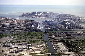
 Aerial view of Indiana Harbor and Ship Canal | |
| Location | East Chicago, Indiana |
| Country | United States |
| Coordinates | 41°40′06″N 87°26′25″W / 41.6684°N 87.4402°W |
| Specifications | |
| Length | 6.75 miles (10.86 km) |
| Locks | None |
| Status | Open |
| Geography | |
| Start point | Lake Michigan |
| End point | Grand Calumet River |
| Branch(es) | Grand Calumet River Branch Lake George Branch |
The Indiana Harbor and Ship Canal is an artificial waterway on the southwest shore of Lake Michigan, in East Chicago, Indiana, which connects the Grand Calumet River to Lake Michigan. It consists of two branch canals, the 1.25 miles (2.01 km) Lake George Branch and the 2 miles (3.2 km) long Grand Calumet River Branch which join to form the main Indiana Harbor Canal.
The canal also functions as a harbor (Indiana Harbor). The outer harbor is sheltered by two bulkheads marked by lights including the Indiana Harbor East Breakwater Light.[1] Ships enter the outer harbor from the north.[1] The inner harbor consists of the canal itself.[1] The entrance to the outer harbor lies near Indiana Shoals, which extend up to 5 miles offshore, where water depths are as shallow as 15 feet.[1]
In 2002, Indiana Harbor was the 45th busiest harbor in the United States, handling almost 13,300,000 short tons (12,000,000 metric tons) of cargo. Foreign trade accounted for only 500,000 short tons (450,000 metric tons) of that. Indiana Harbor is maintained by the Chicago District of the U.S. Army Corps of Engineers, as authorized by the Rivers and Harbors Act of 1913.
- ^ a b c d "Calumet and Indiana Harbors: NOAA Chart 14929" (PDF). Retrieved 2017-11-13.
© MMXXIII Rich X Search. We shall prevail. All rights reserved. Rich X Search
