Back انقلاب حراري Arabic Temperatur inversiyası Azerbaijani هاوا ترسلنمهسی AZB Інверсія (метэаралогія) Byelorussian Температурна инверсия Bulgarian Inversió tèrmica Catalan Inverze teploty vzduchu Czech Gwrthdroad tymheredd Welsh Inversion (meteorologi) Danish Inversionswetterlage German
This article needs additional citations for verification. (May 2020) |
This article may be too technical for most readers to understand. (July 2022) |


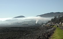
In meteorology, an inversion (or temperature inversion) is a phenomenon in which a layer of warmer air overlies cooler air. Normally, air temperature gradually decreases as altitude increases, but this relationship is reversed in an inversion.[2]
An inversion traps air pollution, such as smog, near the ground. An inversion can also suppress convection by acting as a "cap". If this cap is broken for any of several reasons, convection of any humidity can then erupt into violent thunderstorms. Temperature inversion can cause freezing rain in cold climates.
- ^ "Smoke Filled Canyons, Arizona". earthobservatory.nasa.gov. NASA Earth Observatory.
- ^ "Glossary". forecast.weather.gov. NOAA's National Weather Service. Retrieved July 30, 2024.
© MMXXIII Rich X Search. We shall prevail. All rights reserved. Rich X Search