Back مقاطعة إونيا (ميشيغان) Arabic ایونیا بؤلگهسی، میشیقان AZB Ionia County, Michigan BAR Айония (окръг, Мичиган) Bulgarian আইওনা কাউন্টি, মিশিগান BPY Ionia Gông (Michigan) CDO Ionia County CEB Ionia County Czech Ionia County, Michigan Welsh Ionia County German
Ionia County | |
|---|---|
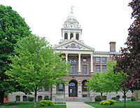
 Ionia County Courthouse in Ionia | |
 Location within the U.S. state of Michigan | |
 Michigan's location within the U.S. | |
| Coordinates: 42°56′N 85°04′W / 42.94°N 85.07°W | |
| Country | |
| State | |
| Founded | March 2, 1831 (created) 1837 (organized)[1] |
| Named for | Ionia |
| Seat | Ionia |
| Largest city | Ionia |
| Area | |
| • Total | 580 sq mi (1,500 km2) |
| • Land | 571 sq mi (1,480 km2) |
| • Water | 8.7 sq mi (23 km2) 1.5% |
| Population (2020) | |
| • Total | 66,804 |
| • Density | 112/sq mi (43/km2) |
| Time zone | UTC−5 (Eastern) |
| • Summer (DST) | UTC−4 (EDT) |
| Congressional district | 2nd |
| Website | ioniacounty |
Ionia County (/aɪˈoʊnjə/ eye-OH-nyə) is a county located in the U.S. state of Michigan. As of the 2020 census, the population was 66,804.[2] The county seat is Ionia.[3] The Ionia County Courthouse was designed by Claire Allen, a prominent southern Michigan architect.
Ionia County is part of the Grand Rapids-Kentwood metropolitan statistical area.
- ^ "Ionia County". Clarke Historical Library, Central Michigan University. Archived from the original on September 6, 2015. Retrieved January 19, 2013.
- ^ "QuickFacts: Ionia County, Michigan". US Census Bureau. Archived from the original on February 13, 2023. Retrieved September 15, 2021.
- ^ "Find a County". National Association of Counties. Archived from the original on May 31, 2011. Retrieved June 7, 2011.
© MMXXIII Rich X Search. We shall prevail. All rights reserved. Rich X Search
