Back نهر إريري Arabic نهر اريرى ARZ Ríu Iriri AST İriri Azerbaijani Rio Iriri BAR Rio Iriri (suba sa Brasil, Pará, lat -3,82, long -52,61) CEB Ирири CV Rio Iriri German Río Iriri Spanish Rio Iriri French
| Iriri River | |
|---|---|
 | |
| Native name |
|
| Location | |
| Country | Brazil |
| Physical characteristics | |
| Source | |
| • location | Pará, Brazil |
| • elevation | 619 m (2,031 ft) |
| Mouth | Xingu River |
• coordinates | 3°49′00″S 52°36′20″W / 3.81667°S 52.60556°W |
• elevation | 116 m (381 ft) |
| Length | 1,151 km (715 mi)[2] |
| Basin size | 141,943 km2 (54,804 sq mi)[2] |
| Discharge | |
| • location | Confluence of Xingu (near mouth) |
| • average | 3,028 m3/s (106,900 cu ft/s)[2] |
| • minimum | 56.3 m3/s (1,990 cu ft/s)[2] |
| • maximum | 14,025 m3/s (495,300 cu ft/s)[2] |
| Discharge | |
| • location | Pedra do Ó gauge station (130 km upstream of mouth - Basin size 123,827 km2 (47,810 sq mi) |
| • average | 2,748 m3/s (97,000 cu ft/s)[2] |
| • minimum | 49 m3/s (1,700 cu ft/s)[2] |
| • maximum | 12,235 m3/s (432,100 cu ft/s)[2] |
| Basin features | |
| Tributaries | |
| • left | Curuá River, Catete River, Chiché River, Ipiranga River |
| • right | Novo River, Carajarí River, Xinxim River, Iriri Novo River |
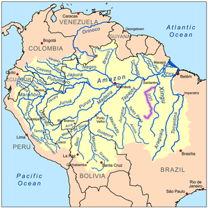
The Iriri River (Portuguese: Rio Iriri, Portuguese pronunciation: [ˈʁiu iɾiˈɾi]; Mẽbêngôkre: Kororoti, [kɔˌɾɔɾɔˈti][1]: 40 ) is a large tributary of the Xingu River in Brazil, in the state of Pará. It is 1,300 km (810 mi) long making it the 116th longest river in the world (with Krishna River, India) and the 15th longest in the Amazon basin. The headwaters are the traditional home of the Panará people.
- ^ a b Passos, João Lucas Moraes (2018). Caminhos mẽbêngôkre: andando, nomeando, sentando sobre a terra (Ph.D. thesis). Brasília: Universidade de Brasília.
- ^ a b c d e f g h "Conhecimento Técnico e a regulação ambiental na Amazônia: A utilização da bacia hidrográfica nos EIA/RIMA das UHE do Rio Madeira e de Belo Monte". 2015.
© MMXXIII Rich X Search. We shall prevail. All rights reserved. Rich X Search