Back Isjim Afrikaans نهر إيشيم Arabic نهر ايشيم ARZ İşim çayı Azerbaijani ایشیم چایی AZB Ишем (йылға) Bashkir Ішым (рака) Byelorussian Ішым (рака) BE-X-OLD Ишим Bulgarian ইশিম নদী Bengali/Bangla
| Ishim | |
|---|---|
 The river Ishim in Astana, a popular thoroughfare in the winter when it is frozen over. | |
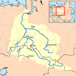
 Map of the Ob–Irtysh drainage basin showing the Ishim River | |
| Location | |
| Country | Kazakhstan, Russia |
| Physical characteristics | |
| Source | Kazakh Uplands |
| • location | Sarybel District, Kazakhstan |
| • coordinates | 50°37′55″N 73°16′01″E / 50.632°N 73.267°E |
| • elevation | 485 m (1,591 ft) |
| Mouth | Irtysh |
• location | Ust-Ishim, Russia |
• coordinates | 57°41′53″N 71°11′51″E / 57.6981°N 71.1975°E |
• elevation | 42 m (138 ft) |
| Length | 2,450 km (1,520 mi) |
| Basin size | 177,000 km2 (68,000 sq mi) |
| Discharge | |
| • average | 56.3 m3/s (1,990 cu ft/s) |
| Basin features | |
| Progression | Irtysh→ Ob→ Kara Sea |
 | |
The Ishim (Russian: Иши́м, romanized: Ishim; Kazakh: Есіл, romanized: Esil) is a river running through Kazakhstan and Russia. It is 2,450 kilometres (1,520 mi) long, and has a drainage basin of 177,000 square kilometres (68,000 sq mi).[1] Its average discharge is 56.3 cubic metres per second (1,990 cu ft/s). It is a left tributary of the Irtysh. The Ishim is partly navigable in its lower reaches. The upper course of the Ishim passes through Astana, the capital of Kazakhstan. In Russia, the course of the river travels through a vast marshland, and has countless meanders and oxbow lakes. The river freezes from late November until March.
- ^ "Река ИШИМ in the State Water Register of Russia". textual.ru (in Russian).
© MMXXIII Rich X Search. We shall prevail. All rights reserved. Rich X Search