Back ঈশ্বরদী উপজেলা Bengali/Bangla ঈশ্বরদী উপজিলা BPY Ishwardi Upazila CEB Ishwardi Spanish ایشواردی Persian Ishwardi French ईश्वरदी उपज़िला Hindi Ishwardi Italian ईश्वरदी उपजिल्ला Nepali Ишварди (подокруг) Russian
Ishwardi
ঈশ্বরদী | |
|---|---|
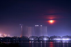
 Rooppur Nuclear Power Plant, Hardinge Bridge, and Lalon Shah Bridge at the same frame on a moonlit night | |
 | |
| Coordinates: 24°9′N 89°4′E / 24.150°N 89.067°E | |
| Country | |
| Division | Rajshahi |
| District | Pabna |
| Government | |
| • Type | Local government |
| • Body | Upazila Parishad |
| • Upazila Chairman | Md. Nayeb Ali Biswas (Bangladesh Awami League) |
| • Upazila Vice Chairman | Md. Abdus Salam |
| Area | |
| • Total | 250.89 km2 (96.87 sq mi) |
| Elevation | 12.9 m (42.3 ft) |
| Population (2011)[1] | |
| • Total | 313,932 |
| • Density | 1,300/km2 (3,200/sq mi) |
| Time zone | UTC+6 (BST) |
| Postal code | 6620 |
| Website | http://www.ishurdi.pabna.gov.bd |
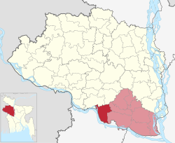
Ishwardi (Bengali: ঈশ্বরদী, Ish-shordi) is an upazila of Pabna District in Rajshahi Division. It is the westernmost upazila of Pabna district. This upazila is a dynamic administrative region with a rich cultural heritage and significant economic importance. Situated in the fertile Gangetic floodplain, Ishwardi Upazila boasts a landscape shaped by the Ganges and its tributaries. This region is known for its agricultural productivity, particularly in the cultivation of rice, vegetables, litchi, sugarcane and other crops. Ishwardi upazila is not only an agricultural hub but also home to various industries, including the Ruppur Nuclear Powerplant and Ishwardi Export Processing Zone, which have contributed to its economic growth. With a harmonious blend of rural and urban areas, this upazila offers a glimpse into the traditional lifestyle and modern developments that coexist within its boundaries.
© MMXXIII Rich X Search. We shall prevail. All rights reserved. Rich X Search