Back Islip (parokya sa Hiniusang Gingharian, Inglatera, Oxfordshire) CEB Islip (Oxfordshire) German Islip (Oxfordshire) Esperanto Islip (Oxfordshire) Spanish آیلیپ، آکسفوردشر Persian Islip (Oxfordshire) French Islip (Oxfordshire) Italian Islip (Oxfordshire) LLD Islip (Oxfordshire) Dutch Islip (Oxfordshire) NB
| Islip | |
|---|---|
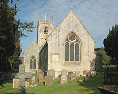
 St Nicholas the Confessor parish church | |
Location within Oxfordshire | |
| Area | 6.42 km2 (2.48 sq mi) |
| Population | 652 (2011 Census) |
| • Density | 102/km2 (260/sq mi) |
| OS grid reference | SP5214 |
| Civil parish |
|
| District | |
| Shire county | |
| Region | |
| Country | England |
| Sovereign state | United Kingdom |
| Post town | KIDLINGTON |
| Postcode district | OX5 |
| Dialling code | 01865 |
| Police | Thames Valley |
| Fire | Oxfordshire |
| Ambulance | South Central |
| UK Parliament | |
Islip (/ˈaɪslɪp/) is a village and civil parish on the River Ray, just above its confluence with the River Cherwell in Oxfordshire, England. It is about 2 miles (3 km) east of Kidlington and about 5 miles (8 km) north of Oxford. The 2011 Census recorded the parish's population as 652.[1]
- ^ "Islip Parish". nomis. Durham University for Office for National Statistics. Retrieved 4 January 2021.
© MMXXIII Rich X Search. We shall prevail. All rights reserved. Rich X Search
