| Israel River | |
|---|---|
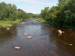
 The Israel River in Lancaster, New Hampshire | |
| Location | |
| Country | United States |
| State | New Hampshire |
| County | Coos |
| Towns | Randolph, Jefferson, Lancaster |
| Physical characteristics | |
| Source | Juncture of Cascade and Castle Brooks |
| • location | White Mountain National Forest |
| • coordinates | 44°20′5″N 71°19′54″W / 44.33472°N 71.33167°W |
| • elevation | 2,274 ft (693 m) |
| Mouth | Connecticut River |
• location | Lancaster |
• coordinates | 44°29′25″N 71°35′43″W / 44.49028°N 71.59528°W |
• elevation | 837 ft (255 m) |
| Length | 23.2 mi (37.3 km) |
| Basin features | |
| Tributaries | |
| • left | South Branch, Red Brook, Mill Brook |
| • right | The Mystic, Stag Hollow Brook, Priscilla Brook, Stalbird Brook, Otter Brook |
The Israel River,[1] sometimes referred to as Israel's River,[2] is a 23.2-mile-long (37.3 km)[3] river in the White Mountains of New Hampshire, in the United States. It rises in the township of Low and Burbank's Grant and runs generally northwest along U.S. Route 2, traversing the towns of Jefferson and Lancaster, before joining the Connecticut River.
- ^ "Israel River". Geographic Names Information System. United States Geological Survey, United States Department of the Interior.
- ^ Museum of Science, Boston (Rev. 6/98). Mount Washington and the Heart of the Presidential Range (Map, 3d Ed). Boston: Globe Pequot Press, Inc. ISBN 0-910146-96-9
- ^ New Hampshire GRANIT state geographic information system
© MMXXIII Rich X Search. We shall prevail. All rights reserved. Rich X Search


