Back Jaisalmer Catalan Jaisalmer (Staat) German Estado de Jaisalmer Spanish Jaisalmer (stato) Italian ریاست جیسلمیر PNB Джайсалмер (княжество) Russian ریاست جیسلمیر SKR Furstendömet Jaisalmer Swedish ஜெய்சல்மேர் சமஸ்தானம் Tamil รัฐไชสัลเมร์ Thai
| Kingdom of Jaisalmer | |||||||||
|---|---|---|---|---|---|---|---|---|---|
| 1156–1947 | |||||||||
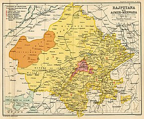
Jailsalmer State (orange) within Rajputana (yellow), 1909. | |||||||||
| Area | |||||||||
• 1931 | 41,600 km2 (16,100 sq mi) | ||||||||
| Population | |||||||||
• 1931 | 76,255 | ||||||||
| History | |||||||||
• Established | 1156 | ||||||||
| 1947 | |||||||||
| |||||||||
| Today part of | Rajasthan, India | ||||||||
| Coat of arms based on The Princely Armory. Publ. by The Office of the Superintendent of Government Printing. Calcutta. 1877 | |||||||||


The Kingdom of Jaisalmer was a Bhati Rajput kingdom in the far-western part of present-day Rajasthan, India, from the mid-12th century CE until 1947. In 1156 CE, Rawal Jaisal moved his capital from Ludarva to Jaisalmer because the former was vulnerable to attacks from Turko-Afghan and Baloch tribes. The descendants of Jaisal continued to exercise absolute control over Jaisalmer until 1818 CE, when a treaty of subsidiary alliance with the British East India Company bringing under British protection and sphere of influence. Known as the Maharawal, the native ruler of the princely state was entitled to a 15-gun salute.[3]
- ^ Schwartzberg, Joseph E. (1978). A Historical atlas of South Asia. Chicago: University of Chicago Press. p. 147, map XIV.4 (a). ISBN 0226742210.
- ^ "Jaisalmer". www.crwflags.com. Retrieved 16 April 2021.
- ^ Imperial Gazetteer of India, v. 24, p. 386.
© MMXXIII Rich X Search. We shall prevail. All rights reserved. Rich X Search


