Back جافا (نيويورك) Arabic Джава (Нью-Йорк) CE Java (Nueva York) Spanish Java (New York) Basque Java (New York) French Java, Nua-Eabhrac Irish Java, New York HT Java (Nowy Jork) Polish Джава (Нью-Йорк) Tatar Джава (Нью-Йорк) Ukrainian
Java, New York | |
|---|---|
 | |
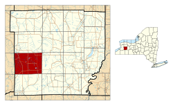
 Location within Wyoming County and New York | |
| Coordinates: 42°39′20″N 78°22′37″W / 42.65556°N 78.37694°W | |
| Country | United States |
| State | New York |
| County | Wyoming |
| Area | |
| • Total | 47.33 sq mi (122.58 km2) |
| • Land | 47.13 sq mi (122.06 km2) |
| • Water | 0.20 sq mi (0.52 km2) |
| Elevation | 1,522 ft (464 m) |
| Population (2010) | |
| • Total | 2,057 |
| • Estimate (2016)[2] | 1,992 |
| • Density | 42.27/sq mi (16.32/km2) |
| Time zone | UTC-5 (Eastern (EST)) |
| • Summer (DST) | UTC-4 (EDT) |
| ZIP code | 14082[3] |
| Area code | 585 |
| FIPS code | 36-38341 |
| GNIS feature ID | 0979104 |
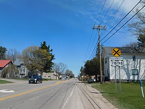
Java (/ˈdʒeɪvə/) is an incorporated town in Wyoming County, New York. The population was 2,057 at the 2010 census. The Town of Java is on the western border of Wyoming County.
- ^ "2016 U.S. Gazetteer Files". United States Census Bureau. Retrieved July 5, 2017.
- ^ Cite error: The named reference
USCensusEst2016was invoked but never defined (see the help page). - ^ "Java Center ZIP Code". zipdatamaps.com. 2022. Retrieved November 11, 2022.
© MMXXIII Rich X Search. We shall prevail. All rights reserved. Rich X Search
