Back مقاطعة جيف ديفيس (تكساس) Arabic Jeff Davis County, Texas BAR Джэф-Дэйвіс (акруга, Тэхас) Byelorussian Джеф Дейвис (окръг, Тексас) Bulgarian জেফ ডেভিস কাউন্টি, টেক্সাস BPY Jeff Davis Gông (Texas) CDO Jeff Davis County (kondado sa Tinipong Bansa, Texas) CEB Jeff Davis County (Texas) Czech Jeff Davis County, Texas Welsh Jeff Davis County (Texas) German
Jeff Davis County | |
|---|---|
County | |
 Jeff Davis County Courthouse in Fort Davis | |
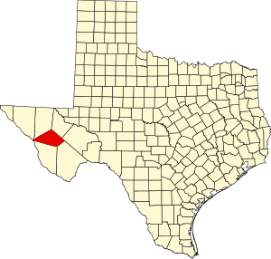
 Location within the U.S. state of Texas | |
 Texas's location within the U.S. | |
| Coordinates: 30°43′N 104°08′W / 30.72°N 104.13°W | |
| Country | |
| State | |
| Founded | 1887 |
| Named for | Jefferson Davis |
| Seat | Fort Davis |
| Largest town | Fort Davis |
| Area | |
| • Total | 2,265 sq mi (5,870 km2) |
| • Land | 2,265 sq mi (5,870 km2) |
| • Water | 0.08 sq mi (0.2 km2) 0% |
| Population (2020) | |
| • Total | 1,996 |
| • Density | 0.88/sq mi (0.34/km2) |
| Time zone | UTC−6 (Central) |
| • Summer (DST) | UTC−5 (CDT) |
| Congressional district | 23rd |
| Website | www |
Jeff Davis County is a county in the U.S. state of Texas. As of the 2020 census, its population was 1,996.[1] Its county seat is Fort Davis.[2] The county is named for Jefferson Davis, who served as the 23rd United States Secretary of War in the 1850s, and as Confederate president.[3]
Jeff Davis County is recognizable for its unique shape; it is a pentagon that has no north–south nor east–west boundaries, save for a six-mile line serving as its southern boundary. It is the only county in the United States that touches a foreign country (Mexico) at a single point. Jeff Davis is one of the nine counties that compose the Trans-Pecos region of West Texas.
The county contains the 270,000-acre (1,100 km2) Texas Davis Mountains American Viticultural Area. About 50 acres (0.2 km2) are "under vine". The McDonald Observatory, owned by the University of Texas at Austin, is located near Fort Davis.
- ^ "Jeff Davis County, Texas". United States Census Bureau. Retrieved February 23, 2021.
- ^ "NACo Explorer - Jeff Davis County". National Association of Counties. Retrieved March 6, 2020.
- ^ Gannett, Henry (1905). The Origin of Certain Place Names in the United States. Govt. Print. Off. p. 168.
© MMXXIII Rich X Search. We shall prevail. All rights reserved. Rich X Search