Back مغارة جعيتا Arabic مغارة جعيتا ARZ Gruta de Jeita Catalan Džajta Czech Jeita-Grotte German Gruta de Jeita Spanish غار جعیتا Persian Grotte de Jeita French જેઇટા ગ્રોટો (લેબેનોન) Gujarati מערת ג'עיתא HE
| Jeita Grotto مغارة جعيتا | |
|---|---|
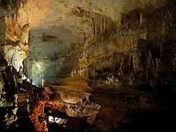
 Upper cave at Jeita with the walkway | |
| Location | Jeita, Lebanon |
| Coordinates | 33°56′36.20″N 35°38′28.89″E / 33.9433889°N 35.6413583°E |
| Length | 9 kilometres (6 mi) |
| Discovery | 1836 |
| Geology | Karstic |
| Entrances | 2 |
| Difficulty | none |
| Access | Jeita Grotto official website |
| Translation | roar or noise (water)[1][2] (Aramaic) |
The Jeita Grotto (Arabic: مغارة جعيتا) is a system of two separate, but interconnected, karstic limestone caves spanning an overall length of nearly 9 kilometres (5.6 mi). The caves are situated in the Nahr al-Kalb river valley within the locality of Jeita, 18 kilometres (11 mi) north of the Lebanese capital Beirut. Though inhabited in prehistoric times, the lower cave was not rediscovered until 1836 by Reverend William Thomson; it can only be visited by boat since it channels an underground river that provides fresh drinking water to more than a million Lebanese.
In 1958, Lebanese speleologists discovered the upper galleries 60 metres (200 ft) above the lower cave which have been accommodated with an access tunnel and a series of walkways to enable tourists safe access without disturbing the natural landscape. The upper galleries house the world's largest known stalactite. The galleries are composed of a series of chambers the largest of which peaks at a height of 12 metres (39 ft).[3]
Aside from being a Lebanese national symbol and a top tourist destination, the Jeita grotto plays an important social, economic and cultural role in the country.[citation needed]
- ^ "Lebanese Maronite villages or towns". Maronite heritage. Retrieved 2008-06-12.
- ^ "Qada' (caza) Keserwan" (PDF). Kesserwan brochure. Lebanese Ministry of Tourism. Archived from the original (.pdf) on 2011-05-16. Retrieved 2009-09-15.
- ^ "Where does the water that feeds the Jeita Grotto come from?". Prestige Magazine. 2014-11-17. Retrieved 2016-12-27.
© MMXXIII Rich X Search. We shall prevail. All rights reserved. Rich X Search