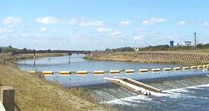
The Jubilee River is a hydraulic channel in southern England. It is 11.6 km (7.2 mi) long[1] and is on average 45 metres (148 feet) wide.[2] It was constructed in the late 1990s and early 2000s to take overflow from the River Thames and so alleviate flooding to areas in and around the towns of Maidenhead, Windsor, and Eton in the counties of Berkshire and Buckinghamshire. It achieves this by taking water from the left (at this point eastern) bank of the Thames upstream of Boulter's Lock near Maidenhead and returning it via the north bank downstream of Eton.[3] Although successful in its stated aims, residents of villages downstream, such as Wraysbury, claim it has increased flooding in those locations.[4]

1.2miles
and weir
- ^ "Windsor & Eton Self Guided Walk Stage 4- Victoria Bridge to Jubilee River". Travellers Toolkit. Archived from the original on 29 August 2010. Retrieved 21 March 2010.
- ^ C. W. Nicol (2 July 2008). "The right way to reconstruct rivers". The Japan Times online. The Japan Times Ltd. Archived from the original on 6 June 2011. Retrieved 20 April 2010.
- ^ Environment Agency – A map indicating the location and route of the Jubilee River
- ^ "Wraysbury residents say Jubilee River is a 'disaster'". BBC News Online. 14 January 2014. Archived from the original on 12 April 2018. Retrieved 5 July 2015.
© MMXXIII Rich X Search. We shall prevail. All rights reserved. Rich X Search

