Back كفر برعم Arabic کفر برعم Persian Biram French כפר בירעם HE Kafr Bir'im ID Kafar Birim Polish Кафр-Бирим Russian Kafr Bir'im Swedish کفر برعم Urdu
Kafr Bir'im
كفر برعم Kefr Berem | |
|---|---|
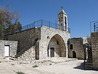
 The church of Kafr Bir'im | |
| Etymology: The village of Bir'im[1] | |
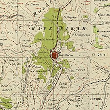
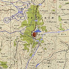
A series of historical maps of the area around Kafr Bir'im (click the buttons) | |
Location within Mandatory Palestine | |
| Coordinates: 33°02′37″N 35°24′51″E / 33.04361°N 35.41417°E | |
| Palestine grid | 189/272 |
| Geopolitical entity | Mandatory Palestine |
| Subdistrict | Safad |
| Date of depopulation | early November 1948[3] |
| Area | |
| • Total | 12,250 dunams (12.25 km2 or 4.73 sq mi) |
| Population (1945) | |
| • Total | 710[2] |
| Cause(s) of depopulation | Expulsion by Yishuv forces |
| Current Localities | Bar'am National Park, Bar'am[4][5] Dovev[5] |
Kafr Bir'im, also Kefr Berem (Arabic: كفر برعم, Hebrew: כְּפַר בִּרְעָם), was a former village in Mandatory Palestine, located in modern-day northern Israel, 4 kilometers (2.5 mi) south of the Lebanese border and 11.5 kilometers (7.1 mi) northwest of Safed. The village was situated 750 meters (2,460 ft) above sea level. "The village stood on a rocky hill only a little higher than the surrounding area and faced north and west."[6]
In ancient times, it was a Jewish village known as Kfar Bar'am. It was an Arab village during the Middle Ages. In the early Ottoman era it was wholly Muslim. During the 19th and early 20th centuries, it was noted as a Maronite Christian village. A church overlooking it at an elevation of 752 meters (2,467 ft) was built on the ruins of an older church destroyed in the earthquake of 1837.
In 1945, 710 people lived in Kafr Bir'im, most of them Christians. Prior to 1948, "A secondary road linked [Kafr Bir'im] to a number of villages in the west and east and led to the coastal highway and the highway to Safad."[6]
The villagers were expelled during the Nakba. A few years later, on September 16, 1953 the village was destroyed by the Israeli Air Force, in order to prevent the villagers' return and in defiance of an Israeli Supreme Court decision recognizing the villager's right to return to their homes.[7][8][9] By 1992, the only standing structure was the church and belltower.[6][additional citation(s) needed]
The village of Iqrit had the same fate.
- ^ Palmer, 1881, p. 76
- ^ Department of Statistics, 1945, p. 10
- ^ Morris, 2004, p. xvi, village #38. Also gives cause of depopulation.
- ^ Morris, 2004, p. xxii, settlement #160
- ^ a b Khalidi, 1992, p. 461
- ^ a b c "Kafr Bir'im — كَفْر بِرْعِم". Interactive Encyclopedia of the Palestine Question – palquest. Retrieved 2023-12-05.
- ^ Cite error: The named reference
Jiryiswas invoked but never defined (see the help page). - ^ Returning to Kafr Bir’im, 2006, BADIL Resource Center
- ^ Ryan, Joseph L. (1973-07-01). "Refugees Within Israel: The Case of the Villagers of Kafr Bir'im and Iqrit". Journal of Palestine Studies. 2 (4). University of California Press: 62–63. doi:10.2307/2535631. ISSN 0377-919X. JSTOR 2535631.
© MMXXIII Rich X Search. We shall prevail. All rights reserved. Rich X Search


