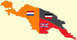
Back Kaiser-Wilhelms-Land ALS Зямля Кайзера Вільгельма Byelorussian Země císaře Viléma Czech Kaiser-Wilhelms-Land German Tierra del Emperador Guillermo Spanish Terre de l'Empereur-Guillaume French Kaiser-Wilhelmsland ID Keizer Wilhelmsland Dutch Keiser Wilhelms land NB Ziemia Cesarza Wilhelma Polish
 Kaiser-Wilhelmsland (in black) 1884–1919 | |
 | |
| Geography | |
|---|---|
| Location | northeastern quarter of the Island of New Guinea, north of the Australian continent |
| Coordinates | 6°50′S 146°40′E / 6.833°S 146.667°E |
| Area | 181,650 km2 (70,140 sq mi) |
| Highest elevation | 4,121 m (13520 ft) |
| Highest point | Saruwaged Massif 6°18′39″S 147°05′27″E / 6.31083°S 147.09083°E |
| Administration | |
| Demographics | |
| Population | 110,000 (1902) |
Kaiser-Wilhelmsland ("Emperor William's Land") formed part of German New Guinea (German: Deutsch-Neuguinea), the South Pacific protectorate of the German Empire. Named in honour of Wilhelm I,[1] who reigned as German Emperor (Kaiser) from 1871 to 1888, it included the northern part of present-day Papua New Guinea. From 1884 until 1920 the territory was a protectorate (German: Schutzgebiet) of the German Empire.[2] Kaiser-Wilhelmsland, the Bismarck Archipelago (including New Mecklenburg and New Pomerania), the northern Solomon Islands, the Caroline Islands, Palau, Nauru, the Northern Mariana Islands, and the Marshall Islands comprised German New Guinea.
Most of the German settlers in Kaiser-Wilhelmsland worked as plantation owners, miners, or government functionaries; the number of European settlers, including non-Germans, was never very high. In 1885, Lutheran and Catholic congregations sent clergy to establish missions; they experienced moderate, but very slow, success with the indigenous peoples. Missionaries and plantation owners alike were limited by tropical diseases and by travel and communication barriers.
The Germans never fully explored the protectorate, though in 1914 the Imperial German Government mounted an expedition to explore and map the interior. Lutheran missionaries were frequently the first Europeans to explore the interior and to examine the different fauna and flora.
Following the outbreak of World War I in July 1914, Australian troops quickly overran the German protectorate (September to November, 1914) and it came under Australian military administration. In accordance with the settlements ending World War I, from 1920 the Commonwealth of Australia, a British dominion, administered Kaiser-Wilhelmsland as part of the Territory of New Guinea, a League of Nations mandate.

- ^ Schlemmer, K. (1906). Geographische Namen: Erklaerung der wichtigsten im Schulgebrauche vorkommenden geographischen Namen [Geographic names: explanation of the most important geographical names occurring in school usage] (reprint ed.). Barsinghausen: Unikum Verlag (published 2013). p. 43. ISBN 9783845722177. Retrieved 24 September 2018.
Kaiser Wilhelmsland, die deutschen Besitzungen, auf Neu-Guinea nach Kaiser Wilhelm I. [Kaiser Wilhelmsland, the German possessions, on New Guinea after Kaiser Wilhelm I.]
- ^ "Samoa Travels". World Digital Library. 1888. Retrieved 12 July 2013.
© MMXXIII Rich X Search. We shall prevail. All rights reserved. Rich X Search