Back كلات (خراسان الرضوية) Arabic Kəlat Azerbaijani Калат (Іран) Byelorussian کلات Persian Kalat (Iran) French Քալաթ Armenian Kalat Italian Kelat Kurdish Kalat, Khorasan Malagasy کلات PNB
Kalat
Persian: كلات | |
|---|---|
City | |
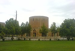
 Sun Palace of the Afsharid dynasty | |
| Coordinates: 36°59′42″N 59°45′46″E / 36.99500°N 59.76278°E[1] | |
| Country | Iran |
| Province | Razavi Khorasan |
| County | Kalat |
| District | Central |
| Population (2016)[2] | |
| • Total | 7,687 |
| Time zone | UTC+3:30 (IRST) |
| • Summer (DST) | UTC+4:30 (IRDT) |
| Kalat, Razavi Khorasan at GEOnet Names Server | |
Kalat (Persian: كلات)[a] is a city in the Central District of Kalat County, Razavi Khorasan Province, Iran, serving as capital of both the county and the district.[4] Nader Shah governed the area after the fall of the Safavids.[5]
- ^ OpenStreetMap contributors (30 April 2023). "Kalat, Kalat County" (Map). OpenStreetMap (in Persian). Retrieved 30 April 2023.
- ^ Cite error: The named reference
2016 censuswas invoked but never defined (see the help page). - ^ Kalat, Razavi Khorasan can be found at GEOnet Names Server, at this link, by opening the Advanced Search box, entering "-3068804" in the "Unique Feature Id" form, and clicking on "Search Database".
- ^ Aref, Mohammad Reza (18 December 1381). "Letter of approval regarding divisional reforms in Khorasan province (Zavin District, Kalat County, Central District)". Laws and Regulations Portal of the Islamic Republic of Iran (in Persian). Ministry of Interior, Political-Defense Commission of the Cabinet of Ministers. Archived from the original on 7 January 2024. Retrieved 7 January 2024.
- ^ Axworthy, Michael (2009). The Sword of Persia: Nader Shah, from Tribal Warrior to Conquering Tyrant. I.B. Tauris. ISBN 978-1845119829.
Cite error: There are <ref group=lower-alpha> tags or {{efn}} templates on this page, but the references will not show without a {{reflist|group=lower-alpha}} template or {{notelist}} template (see the help page).
© MMXXIII Rich X Search. We shall prevail. All rights reserved. Rich X Search
