Back قارابورون (مقاطعة) Arabic قارابورون ARZ Qaraburun (İzmir) Azerbaijani Karaburun Catalan Карабурун CE Karaburun İlçesi CEB Karaburun German Karaburun DIQ Karaburun Esperanto Karaburun Spanish
Karaburun | |
|---|---|
District and municipality | |
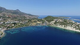
 Aerial view of Karaburun town from the sea | |
 Map showing Karaburun District in İzmir Province | |
| Coordinates: 38°38′N 26°31′E / 38.633°N 26.517°E | |
| Country | Turkey |
| Province | İzmir |
| Government | |
| • Mayor | İlkay Girgin Erdoğan (CHP) |
| Area | 421 km2 (163 sq mi) |
| Elevation | 50 m (160 ft) |
| Population (2022)[1] | 12,200 |
| • Density | 29/km2 (75/sq mi) |
| Time zone | UTC+3 (TRT) |
| Area code | 0232 |
| Website | www |
Karaburun (Greek: Αχιρλί, Achirlí) is a municipality and district of İzmir Province, Turkey.[2] Its area is 421 km2,[3] and its population is 12,200 (2022).[1] The district area roughly corresponds to the peninsula of the same name (Karaburun Peninsula) which spears north of the tourism resorts of neighboring Çeşme and its dependencies and west of the city of İzmir. In fact, the district area is one of the westernmost points of Anatolia. Karaburun town is situated close to the northern tip of the peninsula and checks the entry of the Gulf of İzmir with the town of Foça, another important tourism resort, across the waters. The district's administrative zone is bordered by the districts of Çeşme and Urla in its south and faces the Greek island of Chios to its west.
Karaburun region is comparatively much less visited than Çeşme located in its south, its rate of urbanization at 20 per cent is the lowest across İzmir Province, although it provides an anticlimax to its southern neighbor and the associated attractions especially for those who want to escape the trails of mass tourism. The coasts of the peninsula have beautiful bays and pebble or sand beaches as yet often undiscovered by outsiders, although there is one German vacation village slightly to the north of the district center. Taken as a whole, in contrast with Çeşme, agriculture, fishing and livestock breeding, instead of tourism, remain the principal activities on which the district's economy is based. Karaburun's flora and fauna present particularities distinguishing it from the Anatolian mainland. Karaburun's name echoes in Turkey a very high variety of flower breeds present across its area, and especially narcissus and hyacinth.

- ^ a b "Address-based population registration system (ADNKS) results dated 31 December 2022, Favorite Reports" (XLS). TÜİK. Retrieved 12 July 2023.
- ^ Büyükşehir İlçe Belediyesi, Turkey Civil Administration Departments Inventory. Retrieved 12 July 2023.
- ^ "İl ve İlçe Yüz ölçümleri". General Directorate of Mapping. Retrieved 12 July 2023.
© MMXXIII Rich X Search. We shall prevail. All rights reserved. Rich X Search

