Back كاتيهار ARZ कटिहार जिला AWA कटिहार जिला Bihari কাটিহার জেলা Bengali/Bangla Katihar (distrito) CEB Katihar (Distrikt) German Distrito de Katihar Spanish Katihar barrutia Basque بخش کتیهار Persian District de Katihar French
Katihar District | |
|---|---|
 Fields in Katihar district | |
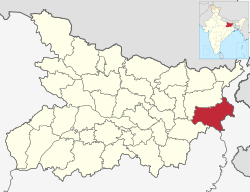
 Location of Katihar district in Bihar | |
| Country | |
| State | Bihar |
| Division | Purnia |
| Headquarters | Katihar |
| Tehsils | 17 |
| Government | |
| • Lok Sabha constituencies | Katihar |
| • Vidhan Sabha constituencies | Katihar, Kadwa, Balrampur, Pranpur, Manihari, Barari Korha |
| Area | |
| • Total | 3,056 km2 (1,180 sq mi) |
| Population (2011) | |
| • Total | 3,071,029 |
| • Density | 1,000/km2 (2,600/sq mi) |
| Demographics | |
| • Sex ratio | 916 |
| Time zone | UTC+05:30 (IST) |
| Vehicle registration | BR-39 |
| Major highways | NH-31, NH-81, NH-131A |
| Website | http://katihar.bih.nic.in/ |
Katihar district is one of the thirty-eight districts of Bihar state in India, and Katihar city is the administrative headquarters of this district. The district is a part of Purnia Division. It is prominently known for its Katihar Junction Railway Station, which is a Category A station on the Barauni–Guwahati line. It has been included in the Aspirational Districts Program of the Government of India since 2018, to improve its socio-economic indicators.[1]
Katihar is the largest maize producing district of Bihar in 2022.[2]
- ^ "vikaspedia Domains". vikaspedia.in. Retrieved 2021-06-13.
- ^ "Bihar Economic Survey 2022-23". state.bihar.gov.in. Retrieved 2023-05-07.
© MMXXIII Rich X Search. We shall prevail. All rights reserved. Rich X Search