Back कावेरी ANP نهر كافيري Arabic نهر كافيرى ARZ Ríu Kaveri AST کافیری چایی AZB Кавери Bulgarian कावेरी नदी Bihari কাবেরী নদী Bengali/Bangla Kaveri Breton Kaveri Catalan
| Kaveri Cauvery | |
|---|---|
 Kaveri River flowing in Srirangapatna | |
 Map of the Kaveri River basin | |
| Location | |
| Country | India |
| States | Karnataka, Tamil Nadu, Kerala, Puducherry |
| Region | Southern India |
| Origin | Kodagu, Karnataka |
| Physical characteristics | |
| Source | Talakaveri, Kodagu, Western Ghats, Karnataka |
| • location | Karnataka, India |
| • coordinates | 12°23′N 75°29′E / 12.383°N 75.483°E |
| • elevation | 1,341 m (4,400 ft) |
| Mouth | Bay of Bengal |
• location | Poompuhar, Tamil Nadu, India |
• coordinates | 11°21′40″N 79°49′46″E / 11.36111°N 79.82944°E |
• elevation | 0 m (0 ft) |
| Length | 805 km (500 mi)[1] |
| Basin size | 81,155 km2 (31,334 sq mi) |
| Discharge | |
| • location | Lower Caleroon Anicut (58.5 km upstream of mouth; Basin size: 78,783 km2 (30,418 sq mi) |
| • average | (Period: 1998-2022)927.65 m3/s (32,760 cu ft/s)[2] 677 m3/s (23,900 cu ft/s) |
| • minimum | 144 m3/s (5,100 cu ft/s)[2] |
| • maximum | 4,075 m3/s (143,900 cu ft/s)[2] |
| Discharge | |
| • location | Grand Anicut (South; 140 km upstream of mouth; Basin size: 74,004 km2 (28,573 sq mi)[3] to 75,506 km2 (29,153 sq mi)[4] |
| • average | (Period: 1976-1979)400.716 m3/s (14,151.2 cu ft/s)[3] (Period: 1998-2022)1,151.2 m3/s (40,650 cu ft/s)[4] |
| • minimum | 78 m3/s (2,800 cu ft/s)[4] |
| • maximum | 4,916 m3/s (173,600 cu ft/s)[4] |
| Basin features | |
| Tributaries | |
| • left | Harangi, Hemavati, Shimsha, Arkavati, Sarabanga, Thirumanimutharu |
| • right | Lakshmana Tirtha, Kabini, Bhavani, Noyyal, Amaravati, Moyar |
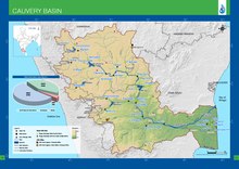
The Kaveri (also known as Cauvery, the anglicised name) is one of the major Indian rivers flowing through the states of Karnataka and Tamil Nadu. The Kaveri River rises at Talakaveri in the Brahmagiri range in the Western Ghats, Kodagu district of the state of Karnataka, at an elevation of 1,341 m above mean sea level and flows for about 800 km before its outfall into the Bay of Bengal. It reaches the sea in Poompuhar, in Mayiladuthurai district. It is the third largest river – after Godavari and Krishna – in southern India, and the largest in the state of Tamil Nadu, which, on its course, bisects the state into north and south. In ancient Tamil literature, the river was also called Ponni (the golden mother, in reference to the fine silt it deposits).[5][6][7]
The Kaveri is a sacred river to the people of Southern India and is worshipped as the Goddess Kaveriamma (Mother Cauvery). It is considered to be among the seven holy rivers of India.[8] It is extensively used for agriculture in both Karnataka and Tamil Nadu.
The catchment area of the Kaveri basin is estimated to be 81,155 square kilometres (31,334 sq mi) with many tributaries including Harangi, Hemavati, Kabini, Bhavani, Lakshmana Tirtha, Noyyal, and Arkavati. The river basin covers three states and a Union Territory as follows: Tamil Nadu, 43,868 square kilometres (16,938 sq mi); Karnataka, 34,273 square kilometres (13,233 sq mi); Kerala, 2,866 square kilometres (1,107 sq mi); and Puducherry, 148 square kilometres (57 sq mi).[9] In Chamarajanagar district it forms the island of Shivanasamudra, on either side of which are the scenic Shivanasamudra Falls that descend about 100 metres (330 ft).[10] The river is the source for an extensive irrigation system and for hydroelectric power.[11] The river has supported irrigated agriculture for centuries and served as the lifeblood of the ancient kingdoms and modern cities of southern India. Access to the river's waters has pitted Indian states against each other for decades. It was profusely described in the Tamil Sangam literature and is held in great reverence in Hinduism. The Kaveri River delta is a thickly populated delta, one which is frequently affected by tropical cyclones formed in the Bay of Bengal.
- ^ "INTEGRATED HYDROLOGICAL DATA BOOK" (PDF). Central Water Commission, India. p. 92. Archived from the original (PDF) on 2 April 2016. Retrieved 13 November 2017.
- ^ a b c "River Discharge and Reservoir Storage Changes Using Satellite Microwave Radiometry - 2043".
- ^ a b "Gauging Station - Data Summary". RivDis. Archived from the original on 4 October 2013. Retrieved 1 October 2013.
- ^ a b c d "River Discharge and Reservoir Storage Changes Using Satellite Microwave Radiometry - 2042".
- ^ "Daughter of Ponni". indianexpress. 27 April 2014. Retrieved 27 April 2014.
- ^ "Cauvery Chronicles II: Ponni's Perish". newslaundry. Retrieved 8 February 2020.
- ^ "The death of a river". millenniumpost. 11 June 2019. Retrieved 11 June 2019.
- ^ "Cauvery basin: its culture, places of historical significance, birth place, climate, precipitation, catchment, tributaries, state-wise spread, landuse". www.indiawaterportal.org. Retrieved 12 May 2020.
- ^ "INTEGRATED HYDROLOGICAL DATA BOOK" (PDF). Archived from the original (PDF) on 24 September 2015. Retrieved 6 September 2012.
- ^ "World Waterfall Database". Archived from the original on 14 November 2006. Retrieved 9 November 2006.
- ^ "Shivasamudram Falls". cauvery.com. Retrieved 11 November 2006.
© MMXXIII Rich X Search. We shall prevail. All rights reserved. Rich X Search