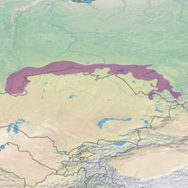
| Kazakh forest steppe | |
|---|---|
 Open mine near Magnitogorsk, Russia, at the western edge of the Kazakh forest steppe | |
 Ecoregion territory (in purple) | |
| Ecology | |
| Realm | Palearctic |
| Biome | temperate grasslands, savannas, and shrublands |
| Borders | |
| Geography | |
| Area | 422,360 km2 (163,070 sq mi) |
| Countries | |
| Conservation | |
| Protected | 50,222 km2 (12%)[1] |
The Kazakh forest steppe ecoregion (WWF ID: PA0809) is a long thin strip of transition zone between the forested taiga of Siberian Russia (to the north), and the Kazakh steppe to the south. The ecoregion stretches over 2,000 km from the southern Ural mountains in the west to the foothills of Altai mountains in the east, yet averages only 200 km from south to north across its length. Because the region is farther inland than European forest steppe, and some 300 to 500 km farther north, the climate is more continental and with less precipitation the tree cover more sparse. The ecoregion is in the Temperate grasslands, savannas, and shrublands biome, and the Palearctic realm, with a Humid Continental climate. It covers 420,614 km2 (162,400 sq mi).[2]
- ^ Eric Dinerstein, David Olson, et al. (2017). An Ecoregion-Based Approach to Protecting Half the Terrestrial Realm, BioScience, Volume 67, Issue 6, June 2017, Pages 534–545; Supplemental material 2 table S1b. [1]
- ^ "Kazakh forest steppe". Ecoregions of the World. GlobalSpecies.org. Archived from the original on October 19, 2018. Retrieved October 14, 2018.
© MMXXIII Rich X Search. We shall prevail. All rights reserved. Rich X Search
