Back كيلونغ Arabic كيلونج ARZ Keelung AST Kiilunq Azerbaijani Keelung Catalan Giĕ-lè̤ng CDO Keelung (kapital sa lalawigan) CEB Ťi-lung Czech Keelung German Ĉilun Esperanto
Keelung
基隆市 Kīrun, Ke-lung, Chilung | |
|---|---|
| Keelung City | |
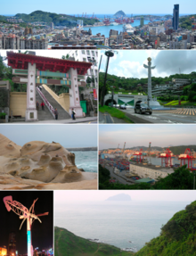
Top: skyline of downtown Keelung Second left: Dawulun Fort Second right: night view of downtown Keelung Third left: Zhengbin Fishing Port Colorful House Third right: Keelung Maritime Plaza and Keelung Main Station Bottom left: Keelung Outer Harbor and Keelung Islet Bottom right: Heping Island Park | |
| Nickname: The Rainy Port (雨港) | |
 Location in Taiwan | |
| Coordinates: 25°08′N 121°44′E / 25.133°N 121.733°E | |
| Country | |
| Province | |
| Region | Northern Taiwan |
| Districts | 7[1] |
| Founded as La Santisima Trinidad | 1626 |
| Part of Taihoku Prefecture | 17 April 1895 |
| Provincial city status | 11 November 1945 |
| City seat | Zhongzheng District |
| Government | |
| • Body | |
| • Mayor | George Hsieh (KMT) |
| Area | |
| • Total | 132.7589 km2 (51.2585 sq mi) |
| • Rank | 18 of 22 |
| Population (October 2023)[2] | |
| • Total | 362,487 |
| • Rank | 16 of 22 |
| • Density | 2,700/km2 (7,100/sq mi) |
| Time zone | UTC+8 (National Standard Time) |
| Postal code | 200–206 |
| Area code | (0)32 |
| ISO 3166 code | TW-KEE |
| – Bird | Eagle |
| – Flower | Common crepe myrtle |
| – Tree | Formosan Sweet-gum |
| English | Keelung/KLC |
| Chinese | 基隆/基市 |
| Website | www |
| Keelung City | |||||||||||||||||||||||||||||||||||||
|---|---|---|---|---|---|---|---|---|---|---|---|---|---|---|---|---|---|---|---|---|---|---|---|---|---|---|---|---|---|---|---|---|---|---|---|---|---|
| Chinese name | |||||||||||||||||||||||||||||||||||||
| Chinese | 基隆市 | ||||||||||||||||||||||||||||||||||||
| |||||||||||||||||||||||||||||||||||||
| Taiwanese Hokkien Name | |||||||||||||||||||||||||||||||||||||
| Traditional Chinese | 雞籠市 | ||||||||||||||||||||||||||||||||||||
| Simplified Chinese | 鸡笼市 | ||||||||||||||||||||||||||||||||||||
| |||||||||||||||||||||||||||||||||||||
| Japanese name | |||||||||||||||||||||||||||||||||||||
| Kanji | 基隆市 | ||||||||||||||||||||||||||||||||||||
| Kana | キールンし | ||||||||||||||||||||||||||||||||||||
| Hiragana | きーるんし | ||||||||||||||||||||||||||||||||||||
| Katakana | キールンシ | ||||||||||||||||||||||||||||||||||||
| |||||||||||||||||||||||||||||||||||||

Keelung (/kiːˈlʊŋ/ kee-LUUNG;[3] Hokkien: Ke-lâng), Chilung or Jilong (/dʒiːˈlʊŋ/ jee-LUUNG;[3] pinyin: Jīlóng), officially known as Keelung City, is a major port city situated in the northeastern part of Taiwan. The city is part of the Taipei–Keelung metropolitan area with neighboring New Taipei City and Taipei. Nicknamed the Rainy Port for its frequent rain and maritime role, the city is Taiwan's second largest seaport (after Kaohsiung), and was the world's 7th largest port in 1984.
In 1626, the Spanish established Fort San Salvador at present-day Keelung, an area inhabited by Taiwanese indigenous peoples. Control of the area eventually passed to the Qing dynasty. Fighing between China and Europeans around Keelung occurred in the 19th century during the First Opium War and the Sino-French War. The island of Taiwan was ceded to the Empire of Japan in 1895 after the First Sino-Japanese War; under Japanese rule the city was called Kirun. Keelung became part of Taiwan Province under the Republic of China after 1945. Administratively, the city became a first-level subdivision in 2018 after the provincial government was abolished.
- ^ Cite error: The named reference
govklwas invoked but never defined (see the help page). - ^ 人口統計. www.klcg.gov.tw (in Chinese). Archived from the original on 29 May 2016. Retrieved 6 June 2016.
- ^ a b "Jilong". Merriam-Webster.com Dictionary.
© MMXXIII Rich X Search. We shall prevail. All rights reserved. Rich X Search


