Back کمسینق AZB Kemsing (lungsod) CEB Kemsing Welsh Kemsing Spanish کمسینگ Persian Kemsing French Kemsing Italian Kemsing LLD Kemsing Dutch Kemsing Polish
| Kemsing | |
|---|---|
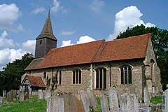
 Church of St Mary | |
Location within Kent | |
| Population | 4,014 (2001)[1] 4,218 (2011)[2] |
| OS grid reference | TQ545591 |
| District | |
| Shire county | |
| Region | |
| Country | England |
| Sovereign state | United Kingdom |
| Post town | Sevenoaks |
| Postcode district | TN15 |
| Dialling code | 01732 and 01959 |
| Police | Kent |
| Fire | Kent |
| Ambulance | South East Coast |
| UK Parliament | |
Kemsing is a village and civil parish in the Sevenoaks district of Kent, England. The parish lies on the scarp face of the North Downs, 20 miles south east of Central London and 4 miles (6 km) north east of Sevenoaks. Also in the parish there are the hamlets of Heaverham, 1 mile (2 km) to the east and Noah's Ark 0.5 miles (1 km) to the south. The population of the civil parish in 2001 was 4,014 persons, increasing to a population of 4,218 at the 2011 Census.[2]

- ^ "Kemsing CP". Neighbourhood Statistics. Retrieved 20 August 2007.
- ^ a b "Civil Parish population 2011". Neighbourhood Statistics. Office for National Statistics. Retrieved 19 September 2016.
© MMXXIII Rich X Search. We shall prevail. All rights reserved. Rich X Search
