Back الخارجة (مدينة) Arabic الخارجه ARZ Oasi d'Al-Kharga Catalan Charga German Ĥarga Esperanto Jariyá Spanish Al-Khārijah Estonian خارجه Persian Al-Kharga French खर्ग Hindi
Kharga
الخارجة ϯⲟⲩⲁϩ ⲛ̀ϩⲏⲃ, ϯⲟⲩⲁϩ ⲙ̀ⲯⲟⲓ | |
|---|---|
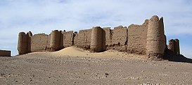
Clockwise from top: Temple of Hibis, qanat shaft near Qasr al-Labakha fortress, Deir al-Munira fortress, Umm al-Dabadib fortress, Kharga Rest-house, Kharga Mosque | |
| Coordinates: 25°26′56″N 30°32′24″E / 25.44889°N 30.54000°E | |
| Country | |
| Governorate | New Valley |
| Area | |
| • Total | 1,017 km2 (393 sq mi) |
| Elevation | 32 m (105 ft) |
| Population (2021)[1] | |
| • Total | 101,283 |
| • Density | 100/km2 (260/sq mi) |
| Time zone | UTC+2 (EST) |
The Kharga Oasis (Arabic: الخارجة al-Ḫāriǧa, pronounced [elˈxæɾɡæ]) lit. 'the outer'; Coptic: (ϯ)ⲟⲩⲁϩ ⲛ̀ϩⲏⲃ (di)wah enhib, "Oasis of Hib", (ϯ)ⲟⲩⲁϩ ⲙ̀ⲯⲟⲓ (di)wah empsoi "Oasis of Psoi") is the southernmost of Egypt's five western oases. It is located in the Western Desert, about 200 km (125 miles) to the west of the Nile valley. "Kharga" or "El Kharga" is also the name of a major town located in the oasis, the capital of New Valley Governorate.[2] The oasis, which was known as the 'Southern Oasis' to the Ancient Egyptians, the 'outer' (he Esotero) to the Greeks[3] and Oasis Magna to the Romans, is the largest of the oases in the Libyan desert of Egypt. It is in a depression about 160 km (100 miles) long and from 20 km (12 miles) to 80 km (50 miles) wide.[4] Its population is 67,700 (2012).
- ^ a b c "Al-Wāḥāt al-Khārijah (Kism (urban and rural parts), Egypt) - Population Statistics, Charts, Map and Location". citypopulation.de. Retrieved 17 March 2023.
- ^ Ball, J. 1900. Kharga Oasis: its topography and geology. Survey Department, Public Works Ministry, Geological Survey Report 1899, Part II. Cairo: National Printing Department, 116 pp.
- ^ Maciej Paprocki, Roads in the Deserts of Roman Egypt: Analysis, Atlas, Commentary (Oxbow, 2019), p. 259.
- ^ Introduction to Kharga Oasis
© MMXXIII Rich X Search. We shall prevail. All rights reserved. Rich X Search


