Khulda
خُلدة Khuldeh | |
|---|---|
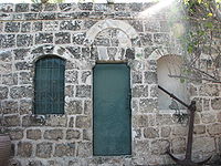
 The largest remaining house in Khulda | |
| Etymology: "the perpetual"[1][2] | |
A series of historical maps of the area around Khulda (click the buttons) | |
Location within Mandatory Palestine | |
| Coordinates: 31°49′10″N 34°54′14″E / 31.81944°N 34.90389°E | |
| Palestine grid | 141/136 |
| Geopolitical entity | Mandatory Palestine |
| Subdistrict | Ramle |
| Date of depopulation | April 6, 1948[5] |
| Area | |
| • Total | 9,461 dunams (9.461 km2 or 3.653 sq mi) |
| Population (1945) | |
| • Total | 280[3][4] |
| Cause(s) of depopulation | Military assault by Yishuv forces |
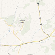
| Current Localities | Mishmar David[6] |
Khulda (Arabic: خُلدة), also Khuldeh, was a Palestinian Arab village located 12 kilometers (7.5 mi) south of Ramla in the Mandatory Palestine. Known as Huldre to the Crusaders, it is also mentioned in documents dating to the periods of Mamluk, Ottoman, and Mandatory rule over Palestine. During the 1948 war, the village was depopulated as part of Operation Nachshon and was subsequently destroyed. The Israeli kibbutz of Mishmar David was established that same year on land belonging to the village.
- ^ Conder, 2009, p. 268.
- ^ Palmer, 1881, p. 268
- ^ Department of Statistics, 1945, p. 29
- ^ a b Government of Palestine, Department of Statistics. Village Statistics, April, 1945. Quoted in Hadawi, 1970, p. 67
- ^ Morris, 2004, p. xix, village #261. Also gives cause of depopulation.
- ^ Morris, 2004, p. xxi, settlement #37
© MMXXIII Rich X Search. We shall prevail. All rights reserved. Rich X Search


