Back Kikaiga-shima CEB Kikaijima German Kikaijima Spanish کیکایجیما Persian Kikai-shima French Kikaijima Italian 喜界島 Japanese 기카이섬 Korean Kikaijima Swedish Кікаідзіма Ukrainian
Native name: 喜界島, Kikai-ga-jima Nickname: Kyaa | |||||
|---|---|---|---|---|---|
 | |||||
 | |||||
| Geography | |||||
| Location | East China Sea[clarification needed] | ||||
| Coordinates | 28°19′35″N 129°58′27″E / 28.32639°N 129.97417°E | ||||
| Archipelago | Amami Islands | ||||
| Area | 56.93 km2 (21.98 sq mi) | ||||
| Coastline | 48.6 km (30.2 mi) | ||||
| Highest elevation | 214 m (702 ft) | ||||
| Administration | |||||
Japan | |||||
| Prefectures | Kagoshima Prefecture | ||||
| District | Ōshima District | ||||
| Town | Kikai | ||||
| Demographics | |||||
| Population | 7,657 (2013) | ||||
| Pop. density | 134.49/km2 (348.33/sq mi) | ||||
| Ethnic groups | Ryukyuan, Japanese | ||||
| Japanese name | |||||
| Kanji | 喜界島 | ||||
| Hiragana | きかいじま | ||||
| |||||
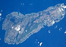
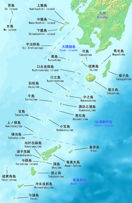
Kikaijima (喜界島, also Kikai-ga-jima; Kikai: キャー Kyaa, Northern Ryukyuan: ききや Kikiya) is one of the Satsunan Islands, classed with the Amami archipelago between Kyūshū and Okinawa.[1]
The island, 56.93 square kilometres (21.98 sq mi) in area, has a population of approximately 7,657 people. Administratively the island forms the town of Kikai, Kagoshima Prefecture. Much of the island is within the borders of the Amami Guntō Quasi-National Park.
- ^ Teikoku's Complete Atlas of Japan, Teikoku-Shoin Co., Ltd., Tokyo, ISBN 4-8071-0004-1
© MMXXIII Rich X Search. We shall prevail. All rights reserved. Rich X Search
