Back Killara CEB کیلارا Persian Killara Italian Killara Malagasy Killara, New South Wales Romanian Killara Swedish کلارا، نیو ساؤتھ ویلز Urdu
| Killara Sydney, New South Wales | |||||||||||||||
|---|---|---|---|---|---|---|---|---|---|---|---|---|---|---|---|
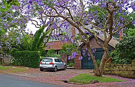
 Residential home, Springdale Road, Killara | |||||||||||||||
 | |||||||||||||||
| Population | 10,620 (2021 census)[1] | ||||||||||||||
| • Density | 2,181/km2 (5,648/sq mi) | ||||||||||||||
| Established | 1821 | ||||||||||||||
| Postcode(s) | 2071 | ||||||||||||||
| Elevation | 120 m (394 ft) | ||||||||||||||
| Area | 4.87 km2 (1.9 sq mi) | ||||||||||||||
| Time zone | AEST (UTC+10) | ||||||||||||||
| • Summer (DST) | AEDT (UTC+11) | ||||||||||||||
| Location | 14 km (9 mi) north-west of Sydney CBD | ||||||||||||||
| LGA(s) | Ku-ring-gai Council | ||||||||||||||
| State electorate(s) | Davidson | ||||||||||||||
| Federal division(s) | Bradfield | ||||||||||||||
| |||||||||||||||
Killara (/kɪlɑːrə/) is a suburb on the Upper North Shore of Sydney in the state of New South Wales, Australia. Killara is located 14 kilometres (8.7 mi) north-west of the Sydney central business district in the local government area of Ku-ring-gai Council. East Killara is a separate suburb and West Killara is a locality within Killara.
- ^ Australian Bureau of Statistics (28 June 2022). "Killara (NSW)". 2021 Census QuickStats. Retrieved 30 January 2024.
© MMXXIII Rich X Search. We shall prevail. All rights reserved. Rich X Search