Back Kings Langley CEB Kings Langley Welsh Kings Langley Danish Kings Langley German Kings Langley (Hertfordshire) Spanish کینگز لنگلی Persian Kings Langley French קינגס לאנגלי HE Kings Langley ID Kings Langley Italian
| Kings Langley | |
|---|---|
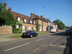
 Kings Langley High Street, looking north. | |
Location within Hertfordshire | |
| Population | 5,072 (Census 2001) 5,214 (Census 2011)[1] |
| OS grid reference | TL067030 |
| District | |
| Shire county | |
| Region | |
| Country | England |
| Sovereign state | United Kingdom |
| Post town | KINGS LANGLEY |
| Postcode district | WD4 |
| Dialling code | 01923 |
| Police | Hertfordshire |
| Fire | Hertfordshire |
| Ambulance | East of England |
| UK Parliament | |
Kings Langley is a village, former manor and civil parish in Hertfordshire, England, 21 miles (34 kilometres) north-west of Westminster in the historic centre of London and to the south of the Chiltern Hills. It now forms part of the London commuter belt. The village is divided between two local government districts by the River Gade with the larger western portion in the Borough of Dacorum and smaller part, to the east of the river, in Three Rivers District. It was the location of Kings Langley Palace and the associated King's Langley Priory, of which few traces survive.
It is situated 2 mi (3 km) south of Hemel Hempstead and 2 mi (3 km) north of Watford.
The earliest mention in surviving documents of the manor of Langalega is in a Saxon charter dated circa 1050. It appears as Langelai in the Domesday Book of 1086, and is recorded as Langel' Regis ("Langley of the King") in 1254. The name means "long wood or clearing".
- ^ "Civil Parish population 2011". Neighbourhood Statistics. Office for National Statistics. Retrieved 30 October 2016.
© MMXXIII Rich X Search. We shall prevail. All rights reserved. Rich X Search
