Back Kinzig (Schwarzwald) ALS نهر كينزيج (نهر) ARZ Kinzig (suba sa Alemanya, Baden-Württemberg Region) CEB Kinzig (biflod til Rhinen) Danish Kinzig (Rhein) German Río Kinzig Spanish Kinzig (Bade-Wurtemberg) French 킨치히강 (라인강) Korean Kinzig ved Rhinen NN Kinzig (Schwarzwald) NB
| Kinzig | |
|---|---|
 The Kinzig in Wolfach | |
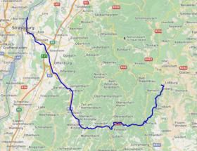
 Course of the Kinzig | |
| Location | |
| Country | Germany |
| State | Baden-Württemberg |
| Reference no. | DE: 234 |
| Physical characteristics | |
| Source | |
| • location | Loßburg |
| • elevation | 682 m |
| Mouth | |
• location | In Kehl-Auenheim |
• elevation | 134 m |
| Length | 93.3 km (58.0 mi) [1] |
| Basin size | 1,403 km2 (542 sq mi) [1] |
| Discharge | |
| • location | at Schwaibach gauge [2] |
| • average | 22.8 m³/s |
| • minimum | Record low: 1.08 m³/s (in 14.09.1919) Average low: 3.62 m³/s |
| • maximum | Average high: 296 m³/s Record high: 914 m³/s (in 24.12.1919) |
| Basin features | |
| Progression | Rhine→ North Sea |
| Landmarks |
|
| Tributaries | |
| • left | Aischbach, Rötenbach, Schiltach, Schiltersbach, Kirnbach, Gutach, Schutter |
| • right | Lohmühle, Kleine Kinzig, Heubach, Sulzbächle, Ippichen, Langenbach, Wolf, Harmersbach |
The Kinzig is a river in southwestern Germany, a right tributary of the Rhine.
It runs for 93 km from the Black Forest through the Upper Rhine River Plains. The Kinzig valley and secondary valleys constitute the largest system of valleys in the Black Forest. Depending on the definition, the Kinzig is either the border between the Northern and Middle Black Forest or part of the Middle Black Forest. It is located entirely inside the State of Baden-Württemberg and its name is supposed to be of Celtic origin. During the last glacial period the Kinzig and the Murg created a common Kinzig-Murg river system.
© MMXXIII Rich X Search. We shall prevail. All rights reserved. Rich X Search