Back مقاطعة نوكس (كنتاكي) Arabic ناکس بؤلگهسی، کنتاکی AZB Knox County, Kentucky BAR Нокс (окръг, Кентъки) Bulgarian কক্স কাউন্টি, কেন্টাকি BPY Knox Gông (Kentucky) CDO Нокс (гуо, Кентукки) CE Knox County (kondado sa Tinipong Bansa, Kentucky) CEB Knox County, Kentucky Welsh Knox County (Kentucky) German
Knox County | |
|---|---|
County | |
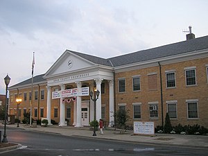
 Knox County courthouse in Barbourville | |
 Location within the U.S. state of Kentucky | |
 Kentucky's location within the U.S. | |
| Coordinates: 36°53′26″N 83°51′15″W / 36.89067°N 83.85404°W | |
| Country | |
| State | |
| Founded | December 19, 1799 |
| Named for | Henry Knox |
| Seat | Barbourville |
| Largest city | Barbourville |
| Area | |
| • Total | 388 sq mi (1,000 km2) |
| • Land | 386 sq mi (1,000 km2) |
| • Water | 1.5 sq mi (4 km2) 0.4% |
| Population (2020) | |
| • Total | 30,193 |
| • Estimate (2023) | 29,794 |
| • Density | 78/sq mi (30/km2) |
| Time zone | UTC−5 (Eastern) |
| • Summer (DST) | UTC−4 (EDT) |
| Congressional district | 5th |
| Website | knoxfiscalcourt |
Knox County is a county located in Appalachia near the southeastern corner of the U.S. state of Kentucky. As of the 2020 census, the population was 30,193.[1] Its county seat is Barbourville.[2] The county is named for General Henry Knox. It is one of the few coal-producing counties in Kentucky that has not suffered massive population loss. Knox County is included in the London, KY Micropolitan Statistical Area.
- ^ "State & County QuickFacts". United States Census Bureau. Retrieved July 13, 2022.
- ^ "Find a County". National Association of Counties. Archived from the original on May 31, 2011. Retrieved June 7, 2011.
© MMXXIII Rich X Search. We shall prevail. All rights reserved. Rich X Search