Back جبل كونجور تاج ARZ Конгур (планински масив) Bulgarian Kongur Shan CEB Kongur Czech Kongur German Kongur Spanish Kongur Tagh Basque قونگورداغ Persian Kongur Tagh Finnish Kongur French
| Kongur Tagh | |
|---|---|
| Kongkhoerh | |
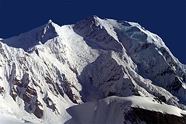
 South face of Kongur Tagh | |
| Highest point | |
| Elevation | 7,649 m (25,095 ft)[1] Ranked 37th |
| Prominence | 3,585 m (11,762 ft)[1] Ranked 49th |
| Listing | Ultra |
| Coordinates | 38°35′39″N 75°18′48″E / 38.59417°N 75.31333°E[1] |
| Geography | |
| Location | Akto County, Xinjiang, China |
| Parent range | Pamir Mountains |
| Climbing | |
| First ascent | 1981 by British team |
| Easiest route | Rock/snow/ice climb |
Kongur Tagh (Kyrgyz: Коңур Тоо; Uyghur: قوڭۇر تاغ, Коңур Тағ, meaning "Brown Mountain"; Mongolian: Хонгор Таг, (Хонгор/Kongur/Kongur is Mongolian word for the color Mongolians use for Buckskin colored horse) Hongor Tag; simplified Chinese: 公格尔峰; traditional Chinese: 公格爾峰; pinyin: Gōnggé'ěr Fēng; also referred to as Kongur) is the highest peak in the Pamir Mountains, and also the highest mountain wholly within the Xinjiang Uyghur Autonomous Region, China. With an elevation of 7,649 metres (25,095 ft), it is also the highest mountain outside of the Hindu Kush/Karakoram and Himalaya ranges.
- ^ a b c "China II: Sinkiang - Xinjiang". Peaklist.org. Retrieved 2014-05-26.
© MMXXIII Rich X Search. We shall prevail. All rights reserved. Rich X Search
