Back قورخو تئلی AZB Korkuteli Catalan Коркутели CE Korkuteli İlçesi CEB Korkuteli German Korkuteli DIQ Κορκούτελι Greek Korkuteli Esperanto قورقودالی Persian Korkuteli Finnish
Korkuteli | |
|---|---|
District and municipality | |
 Korkuteli; east view of the city from the dam. | |
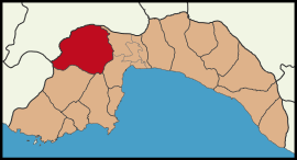
 Map showing Korkuteli District in Antalya Province | |
| Coordinates: 37°04′N 30°12′E / 37.067°N 30.200°E | |
| Country | Turkey |
| Province | Antalya |
| Government | |
| • Mayor | Saniye Caran (CHP) |
| Area | 2,433 km2 (939 sq mi) |
| Elevation | 1,020 m (3,350 ft) |
| Population (2022)[1] | 56,285 |
| • Density | 23/km2 (60/sq mi) |
| Time zone | UTC+3 (TRT) |
| Postal code | 07800 |
| Area code | 0242 |
| Website | www |
Korkuteli is a municipality and district of Antalya Province, Turkey.[2] Its area is 2,433 km2,[3] and its population is 56,285 (2022).[1] It is 56 km (35 mi) north-west of the city of Antalya. It was previously called İstanoz[4][5] or Stenez.[6]
- ^ a b "Address-based population registration system (ADNKS) results dated 31 December 2022, Favorite Reports" (XLS). TÜİK. Retrieved 22 May 2023.
- ^ Büyükşehir İlçe Belediyesi, Turkey Civil Administration Departments Inventory. Retrieved 8 June 2023.
- ^ "İl ve İlçe Yüz ölçümleri". General Directorate of Mapping. Retrieved 22 May 2023.
- ^ Stillwell, Richard; MacDonald, William L.; McAllister, Marian Holland, eds. (1976). "Isinda (Kişla)". The Princeton Encyclopedia of Classical Sites. Princeton University Press.
- ^ Korkuteli, nisanyanmap.com
- ^ Cite error: The named reference
Sprattwas invoked but never defined (see the help page).
© MMXXIII Rich X Search. We shall prevail. All rights reserved. Rich X Search
