Back Koera Afrikaans كر (نهر) Arabic نهر كورا ARZ Кор (гӀор) AV Kür Azerbaijani کر (قفقاز) چایی AZB Кура (рака) Byelorussian Кура (рака) BE-X-OLD Кура Bulgarian কুরা (কাস্পিয়ান সাগর) Bengali/Bangla
| Kura Mtkvari | |
|---|---|
 | |
 Kura River Basin | |
| Location | |
| Countries | |
| Region | Caucasus |
| Cities | |
| Physical characteristics | |
| Source | Lesser Caucasus |
| • location | Near Kartsakhi Lake, Kars, Turkey |
| • coordinates | 40°40′31″N 42°44′32″E / 40.67528°N 42.74222°E |
| • elevation | 2,740 m (8,990 ft)[1] |
| Mouth | Caspian Sea |
• location | Neftçala, Neftchala Rayon, Azerbaijan |
• coordinates | 40°40′18″N 42°45′55″E / 40.6715688305°N 42.765199064°E 40.67156883058258, 42.76519906444574 |
• elevation | −26.5 m (−87 ft)[2] |
| Length | 1,515 km (941 mi)[3] |
| Basin size | 198,300 km2 (76,600 sq mi)[4] |
| Discharge | |
| • location | directly downstream from Aras River confluence[5] |
| • average | 443 m3/s (15,600 cu ft/s)[5] |
| • minimum | 206 m3/s (7,300 cu ft/s)[6] |
| • maximum | 2,250 m3/s (79,000 cu ft/s)[6] |
| Discharge | |
| • location | border of Georgia and Azerbaijan |
| • average | 378 m3/s (13,300 cu ft/s) |
| Basin features | |
| River system | Caspian Sea basin |
| Tributaries | |
| • left | Liakhvi, Ksani, Aragvi, Iori, Alazani |
| • right | Algeti, Khrami, Tartarchay, Aras |
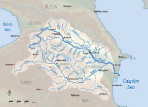
The Kura is an east-flowing river south of the Greater Caucasus Mountains which drains the southern slopes of the Greater Caucasus east into the Caspian Sea. It also drains the north side of the Lesser Caucasus, while its main tributary, the Aras, drains the south side of those mountains. Starting in northeastern Turkey, the Kura flows through Turkey to Georgia, then to Azerbaijan, where it receives the Aras as a right tributary, and enters the Caspian Sea at Neftçala. The total length of the river is 1,515 kilometres (941 mi).
People have inhabited the Caucasus region for thousands of years and first established agriculture in the Kura Valley over 4,500 years ago. Large, complex civilizations eventually grew on the river, but by 1200 CE most were reduced to ruin by natural disasters and foreign invaders. The increasing human use, and eventual damage, of the watershed's forests and grasslands, contributed to a rising intensity of floods through the 20th century. In the 1950s, the Soviet Union started building many dams and canals on the river. Previously navigable up to Tbilisi in Georgia, the Kura is now much slower and shallower, having been harnessed by irrigation projects and hydroelectric power stations. The river is now moderately polluted by major industrial centers like Tbilisi and Rustavi in Georgia.
- ^ Guluzada, Lidiya. "Kura River—Transboundary Watercourse of Caucasus" (PDF). Fondazione Eni Enrico Mattei. Retrieved 2010-03-12.
- ^ "General Background". Caspian Environment Programme. 2004-11-06. Archived from the original on 2001-04-14. Retrieved 2010-03-12.
- ^ Cite error: The named reference
UNDPwas invoked but never defined (see the help page). - ^ Cite error: The named reference
overviewwas invoked but never defined (see the help page). - ^ a b Cite error: The named reference
sedimentwas invoked but never defined (see the help page). - ^ a b "Kura River Discharge at Surra". River Discharge Database. Center for Sustainability and the Global Environment. 1930–1984. Archived from the original on 2010-06-16. Retrieved 2010-03-12.
© MMXXIII Rich X Search. We shall prevail. All rights reserved. Rich X Search