Back Kuskokwimrivier Afrikaans نهر كوسكوكويم Arabic نهر كوسكوكويم ARZ Кускокуюм Bulgarian Riu Kuskokwim Catalan Kuskokwim River CEB Kuskokwim Czech Кускоквим CV Kuskokwim River Danish Kuskokwim River German
| Kuskokwim River | |
|---|---|
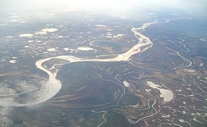
 Aerial photograph of the river | |
 Watershed of the Kuskokwim River in Alaska | |
| Etymology | from the Yupʼik, kusquqviim[1] |
| Native name |
|
| Location | |
| Country | United States |
| State | Alaska |
| Districts | |
| Physical characteristics | |
| Source | confluence of the river's east and north forks |
| • location | near Medfra, Yukon–Koyukuk Census Area |
| • coordinates | 63°05′16″N 154°38′33″W / 63.08778°N 154.64250°W[2] |
| • elevation | 3,655 ft (1,114 m)[3] |
| Mouth | Kuskokwim Bay |
• location | near Eek, Bethel Census Area |
• coordinates | 60°04′59″N 162°20′02″W / 60.08306°N 162.33389°W[2] |
• elevation | 0 ft (0 m)[2] |
| Length | 702 mi (1,130 km)[4] |
| Basin size | 48,000 sq mi (120,000 km2)[5] |
| Discharge | |
| • location | mouth[5] |
| • average | 67,000 cu ft/s (1,900 m3/s)[5] |
The Kuskokwim River or Kusko River (Yupʼik: Kusquqvak; Deg Xinag: Digenegh; Upper Kuskokwim: Dichinanekʼ; Russian: Кускоквим (Kuskokvim)[6][7]) is a river, 702 miles (1,130 km) long, in Southwest Alaska in the United States.[4] It is the ninth largest river in the United States by average discharge volume at its mouth and seventeenth largest by basin drainage area.[8] The Kuskokwim River is the longest river system contained entirely within a single U.S. state.
The river provides the principal drainage for an area of the remote Alaska Interior on the north and west side of the Alaska Range, flowing southwest into Kuskokwim Bay on the Bering Sea. The highest point in its watershed is Mount Russell. Except for its headwaters in the mountains, the river is broad and flat for its entire course, making it a useful transportation route for many types of watercraft, as well as road vehicles during the winter when it is frozen over.[9] It is the longest free flowing river in the United States.
Kuskokwim is a loose transliteration of a Yupʼik word. It is a compound word meaning big slow moving thing.
The Alaska Natives of Kuskokwim are Yupʼik Eskimo on the lower Kuskokwim, Deg Xitʼan Athabaskan on the middle Kuskokwim, Upper Kuskokwim Athabaskan on the upper Kuskokwim, and Koyukon Athabaskan on the North Fork, Lake Minchumina.
- ^ Cite error: The named reference
Brightwas invoked but never defined (see the help page). - ^ a b c "Kuskokwim River". Geographic Names Information System. United States Geological Survey. January 1, 2000. Retrieved May 2, 2011.
- ^ Source elevation derived from Google Earth search using source coordinates.
- ^ a b Benke and Cushing, p. 741
- ^ a b c Benke and Cushing, p. 764
- ^ Карта Российских владений на берегах Восточного океана (1861)
- ^ "Кускоквим". Географический энциклопедический словарь: географические названия. Советская энциклопедия. 1989.
{{cite web}}: Missing or empty|url=(help) - ^ Kammerer, J.C. (1990). "Largest Rivers in the United States". United States Geological Survey. Retrieved May 2, 2011.
- ^ Johnson, Kirk (May 28, 2013). "Health Care Is Spread Thin on Alaskan Frontier". New York Times. Retrieved 3 June 2013.
© MMXXIII Rich X Search. We shall prevail. All rights reserved. Rich X Search