Back كوتاوا Arabic كوتاوا ARZ کوتاوا، کنتاکی AZB Kuttawa Catalan Куттава (Кентукки) CE Kuttawa CEB Kuttawa (Kentucky) Spanish Kuttawa (Kentucky) Basque کوتاوا، کنتاکی Persian Kuttawa French
Kuttawa, Kentucky | |
|---|---|
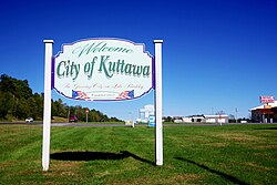
 Welcome sign in Kuttawa | |
 Location in Lyon County, Kentucky | |
| Coordinates: 37°03′34″N 88°06′54″W / 37.05944°N 88.11500°W | |
| Country | United States |
| State | Kentucky |
| County | Lyon |
| Incorporated | 1872 |
| Named for | a Cherokee village |
| Area | |
| • Total | 3.02 sq mi (7.81 km2) |
| • Land | 2.19 sq mi (5.67 km2) |
| • Water | 0.83 sq mi (2.14 km2) |
| Elevation | 463 ft (141 m) |
| Population (2020) | |
| • Total | 629 |
| • Density | 287.48/sq mi (111.02/km2) |
| Time zone | UTC-6 (Central (CST)) |
| • Summer (DST) | UTC-5 (CDT) |
| ZIP code | 42055 |
| Area code | 270 |
| FIPS code | 21-43264 |
| GNIS feature ID | 2404844[2] |
| Website | www |
Kuttawa locally /kəˈtɑːwə/[3] is a home rule-class city in Lyon County, Kentucky, in the United States. The population was 649 as of the 2010 census,[4] up from 596 in 2000.
- ^ "2020 U.S. Gazetteer Files". United States Census Bureau. Retrieved March 18, 2022.
- ^ a b U.S. Geological Survey Geographic Names Information System: Kuttawa, Kentucky
- ^ Cite error: The named reference
renwas invoked but never defined (see the help page). - ^ "Total Population: 2010 Census DEC Summary File 1 (P1), Kuttawa city, Kentucky". data.census.gov. U.S. Census Bureau. Retrieved February 14, 2020.
© MMXXIII Rich X Search. We shall prevail. All rights reserved. Rich X Search