Back مقاطعة لا بلاتا (كولورادو) Arabic La Plata County, Colorado BAR Ла-Плата (акруга) Byelorussian Ла Плата (окръг) Bulgarian লা প্লাটা কাউন্টি, কলোরাডো BPY La Plata Gông (Colorado) CDO Ла-Плата (гуо, Колорадо) CE La Plata County CEB La Plata County Czech La Plata County, Colorado Welsh
La Plata County | |
|---|---|
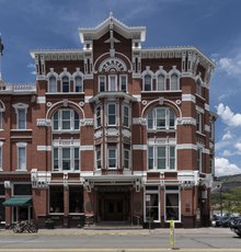 Strater Hotel, opened in 1888 during a mining boom in Durango. | |
 Location within the U.S. state of Colorado | |
 Colorado's location within the U.S. | |
| Coordinates: 37°17′N 107°51′W / 37.29°N 107.85°W | |
| Country | |
| State | |
| Founded | February 10, 1874 |
| Named for | Spanish for "the silver" |
| Seat | Durango |
| Largest city | Durango |
| Area | |
| • Total | 1,700 sq mi (4,000 km2) |
| • Land | 1,692 sq mi (4,380 km2) |
| • Water | 7.6 sq mi (20 km2) 0.4% |
| Population (2020) | |
| • Total | 55,638 |
| • Density | 33/sq mi (13/km2) |
| Time zone | UTC−7 (Mountain) |
| • Summer (DST) | UTC−6 (MDT) |
| Congressional district | 3rd |
| Website | co |
La Plata County is a county located in the U.S. state of Colorado. As of the 2020 census, the population was 55,638.[1] The county seat is Durango.[2] The county was named for the La Plata River and the La Plata Mountains. "La plata" means "the silver" in Spanish.
La Plata County comprises the Durango, CO Micropolitan Statistical Area.[3][4]
The county is home to Durango Rock Shelters Archeology Site, the type site for the Basketmaker II period of Anasazi culture.
- ^ "State & County QuickFacts". United States Census Bureau. Retrieved September 5, 2021.
- ^ "Find a County". National Association of Counties. Retrieved June 7, 2011.
- ^ "OMB Bulletin No. 10-02: Update of Statistical Area Definitions and Guidance on Their Uses" (PDF). Office of Management and Budget. December 1, 2009. Archived (PDF) from the original on January 21, 2017. Retrieved April 19, 2012 – via National Archives.
- ^ See the Colorado census statistical areas.
© MMXXIII Rich X Search. We shall prevail. All rights reserved. Rich X Search