| Lake Alamosa | |
|---|---|
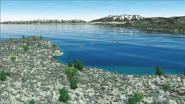
 Simulation of Lake Alamosa's surface, looking towards Blanca Peak | |
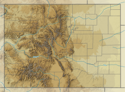
| Location | San Luis Valley, Colorado |
| Coordinates | 37°12′N 105°25′W / 37.200°N 105.417°W |
| Type | former lake |
| Basin countries | United States of America |
Lake Alamosa is a former lake in Colorado. It existed from the Pliocene to the middle Pleistocene in the San Luis Valley, fed by glacial meltwater from surrounding mountain ranges. Water levels waxed and waned with the glacial stages until at highstand the lake (high water level in the lake) reached an elevation of 2,335 meters (7,661 ft) and probably a surface of over 4,000 square kilometers (1,500 sq mi), but only sparse remains of the former waterbody are visible today. The existence of the lake was postulated in the early 19th century and eventually proven in the early 20th century.
The lake eventually overflowed into the Rio Grande river system during the middle Pleistocene. The overflow cut down a valley that eventually drained the lake, leaving only the San Luis Closed Basin as a remnant. The Alamosa Formation is a rock formation left by the lake. Groundwater resources are contained trapped between sediments left by the former lake.
© MMXXIII Rich X Search. We shall prevail. All rights reserved. Rich X Search

