Back بحيرة بيريسا Arabic Lake Berryessa CEB Lake Berryessa German Lago Berryessa Spanish Berryessa järv Estonian Lac Berryessa French Lago Berryessa Italian Lake Berryessa Dutch Lacul Berryessa Romanian Берриесса (водохранилище) Russian
| Lake Berryessa | |
|---|---|
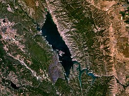
 Satellite photo | |
| Location | Vaca Mountains, Napa County, California |
| Coordinates | 38°35′N 122°14′W / 38.59°N 122.23°W |
| Type | reservoir |
| Primary inflows | Putah Creek, Pope Creek, Capell Creek, Eticuera Creek |
| Primary outflows | Putah Creek[1] |
| Catchment area | 576 sq mi (1,490 km2)[1] |
| Basin countries | United States |
| Managing agency | United States Bureau of Reclamation |
| Max. length | 15.5 mi (24.9 km)[2] |
| Max. width | 3 mi (4.8 km) |
| Surface area | 20,700 acres (8,400 ha)[1] |
| Max. depth | 275 ft (84 m) |
| Water volume | 1,602,000 acre⋅ft (1.976 km3)[1] |
| Shore length1 | 165 mi (266 km) |
| Surface elevation | 443 ft (135 m) |
| Website | www |
| References | [1][2] |
| 1 Shore length is not a well-defined measure. | |

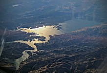
Lake Berryessa is the largest lake in Napa County, California, United States. This reservoir in the Vaca Mountains was formed following the construction of the Monticello Dam on Putah Creek in the 1950s. Since the early 1960s, this reservoir has provided water and hydroelectricity to the North Bay region of the San Francisco Bay Area.
The reservoir was named after the Berryessa family of California; José Jesús and Sexto "Sisto" Berryessa were granted Rancho Las Putas in 1843.
- ^ a b c d e "Dams Owned and Operated by Federal Agencies" (PDF). Archived from the original (PDF) on October 5, 2012. Retrieved September 27, 2012.
- ^ a b "Lake Berryessa". Geographic Names Information System. United States Geological Survey, United States Department of the Interior.
© MMXXIII Rich X Search. We shall prevail. All rights reserved. Rich X Search

