Back Llac Bonneville Catalan Bonneville (jezero) Czech Lake Bonneville German Lago Bonneville Spanish Bonneville'i järv Estonian Lac Bonneville French ימת בונוויל HE Lago Bonneville Italian Боневил (езеро) Macedonian Lake Bonneville Dutch
| Lake Bonneville | |
|---|---|
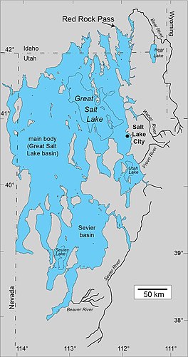
 Map of Lake Bonneville, showing the outline of the Bonneville shoreline, the highest level of the lake. | |
| Location | Utah, Idaho and Nevada |
| Coordinates | 41°N 113°W / 41°N 113°W |
| Type | pluvial lake (a paleolake created by a change in water balance in the basin) |
| Etymology | Benjamin Bonneville |
| Surface area | ~20,000 sq mi (51,000 km2) (at max. lake level) |
| Max. depth | over 980 ft (300 m) |
Lake Bonneville was the largest Late Pleistocene paleolake in the Great Basin of western North America. It was a pluvial lake that formed in response to an increase in precipitation and a decrease in evaporation as a result of cooler temperatures. The lake covered much of what is now western Utah and at its highest level extended into present-day Idaho and Nevada. Many other hydrographically closed basins in the Great Basin contained expanded lakes during the Late Pleistocene, including Lake Lahontan in northwestern Nevada.
© MMXXIII Rich X Search. We shall prevail. All rights reserved. Rich X Search
