Back مقاطعة ليك (كولورادو) Arabic Lake County, Colorado BAR Лейк (акруга, Каларада) Byelorussian Лейк (окръг, Колорадо) Bulgarian লেক কাউন্টি, কলোরাডো BPY Lake Gông (Colorado) CDO Лейк (гуо, Колорадо) CE Lake County (kondado sa Tinipong Bansa, Colorado) CEB Lake County (Colorado) Czech Lake County, Colorado Welsh
Lake County | |
|---|---|
 Courthouse in Leadville, Colorado. | |
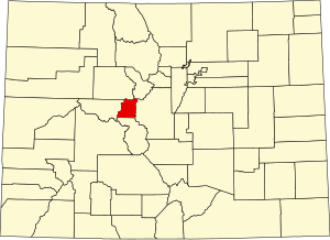
 Location within the U.S. state of Colorado | |
 Colorado's location within the U.S. | |
| Coordinates: 39°11′N 106°22′W / 39.19°N 106.36°W | |
| Country | |
| State | |
| Founded | November 1, 1861 |
| Named for | Twin Lakes in the area |
| Seat | Leadville |
| Largest city | Leadville |
| Area | |
| • Total | 384 sq mi (990 km2) |
| • Land | 377 sq mi (980 km2) |
| • Water | 7.0 sq mi (18 km2) 1.8% |
| Population (2020) | |
| • Total | 7,436 |
| • Density | 20/sq mi (8/km2) |
| Time zone | UTC−7 (Mountain) |
| • Summer (DST) | UTC−6 (MDT) |
| Congressional district | 7th |
| Website | www |

Lake County is a county located in the U.S. state of Colorado. As of the 2020 census, the population was 7,436.[1] The county seat and the only municipality in the county is Leadville.[2] The highest natural point in Colorado and the entire Rocky Mountains is the summit of Mount Elbert in Lake County at 14,440 feet (4,400 meters) elevation.
- ^ "State & County QuickFacts". United States Census Bureau. Retrieved September 5, 2021.
- ^ "Find a County". National Association of Counties. Retrieved June 7, 2011.
© MMXXIII Rich X Search. We shall prevail. All rights reserved. Rich X Search
