Back بحيرة أرومية Arabic ܝܡܬܐ ܕܐܘܪܡܝܐ ARC اروميه (بحيره) ARZ Llagu Urmía AST Urmiya gölü Azerbaijani اورمو گؤلو AZB Урмия (күл) Bashkir Урмія (возера) Byelorussian Урмия (езеро) Bulgarian উর্মিয়া হ্রদ Bengali/Bangla
| Lake Urmia | |
|---|---|
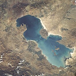
 Lake Urmia from space in 1984 | |
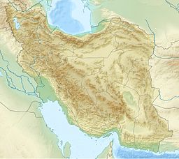
| Coordinates | 37°42′N 45°22′E / 37.700°N 45.367°E |
| Type | salt (hypersaline) lake |
| Primary inflows | Zarriné-Rūd, Simineh-Rūd, Mahabad River, Gadar River, Barandouz River, Shahar River, Nazlou River, Zola River, Kaftar Ali Chay, Aji Chay, Boyuk Chay, Rudkhaneh-ye Qal'eh Chay, Qobi Chay, Rudkhaneh-ye Mordaq, Leylan River; diversion from the Zab River |
| Primary outflows | none: all water entering the lake is lost through evaporation |
| Basin countries | Iran |
| Max. length | 140 km (87 mi) [1995] |
| Max. width | 55 km (34 mi) [1995] |
| Surface area | 2,917 km2 (1,126 sq mi) [2021-april][1] |
| Average depth | 6 to 8 m (20 to 26 ft) [1910–2012][2] |
| Max. depth | 13 to 15 m (43 to 49 ft) [1910–2012][2] |
| Water volume | 5.5 km3 (1.3 cu mi) [2021][1] |
| Salinity | 217–235 g L−1 Na–(Mg)–Cl–(SO4) brine [20th c.][3] 8–11% in spring, 26–28% in late autumn[4] |
| Islands | 102 [1995] (see list) |
| References | [5] |
 | |
| Official name | Lake Urmia [or Orumiyeh] |
| Designated | 23 June 1975 |
| Reference no. | 38[6] |


Lake Urmia[a] is an endorheic salt lake in Iran.[7][8] The lake is located between the provinces of East Azerbaijan and West Azerbaijan in Iran, and west of the southern portion of the Caspian Sea. At its greatest extent, it was the largest lake in the Middle East and the sixth-largest saltwater lake on Earth, with a surface area of approximately 5,200 km2 (2,000 sq mi), a length of 140 km (87 mi), a width of 55 km (34 mi), and a maximum depth of 16 m (52 ft).[9]
By late 2017, the lake had shrunk to 10% of its former size (and 1/60 of water volume in 1998) due to persistent general drought in Iran, but also the damming of the local rivers that flow into it, and the pumping of groundwater from the surrounding area.[10] This dry spell was broken in 2019 and the lake is now filling up once again, due to both increased rain and water diversion from the Zab River under the Urmia Lake Research Programme.[11]
Lake Urmia, along with its approximately 102 (former) islands, is protected as a national park by the Iranian Department of Environment.
- ^ a b Urmia Lake Research Program. Lake Urmia’s surface increased by over 1500 km2 April 11, 2021.
- ^ a b 'Urmia, Lake'. Encyclopedia Iranica
- ^ Cite error: The named reference
Stevens_Djamaliwas invoked but never defined (see the help page). - ^ Urmia Lake. 2012. Encyclopædia Britannica Online. Retrieved 14 August 2015, from https://www.britannica.com/EBchecked/topic/619901/Lake-Urmia
- ^ "Lake Urmia's surface increased by over 1500 km²". Tehran Times. 11 April 2021.
- ^ "Lake Urmia [or Orumiyeh]". Ramsar Sites Information Service. Retrieved 25 April 2018.
- ^ Henry, Roger (2003) Synchronized chronology: Rethinking Middle East Antiquity: A Simple Correction to Egyptian Chronology Resolves the Major Problems in Biblical and Greek Archaeology Algora Publishing, New York, p. 138, ISBN 0-87586-191-1
- ^ E. J. Brill's first encyclopaedia of Islam, 1913–1936, vol. 7, page 1037 citing Strabo and Ptolemy.
- ^ "Britanica". Britannica.com. Retrieved 4 September 2011.
- ^ Stone, Richard (2 September 2015). "Saving Iran's great salt lake". Science. 349 (6252): 1044–5, 1047. Bibcode:2015Sci...349.1044S. doi:10.1126/science.aad1702. PMID 26339009.
- ^ Dudley, Dominic. "Iran's Lake Urmia: How A Dying Salt Lake Is Being Brought Back From The Brink". Forbes. Retrieved 29 May 2020.
Cite error: There are <ref group=lower-alpha> tags or {{efn}} templates on this page, but the references will not show without a {{reflist|group=lower-alpha}} template or {{notelist}} template (see the help page).
© MMXXIII Rich X Search. We shall prevail. All rights reserved. Rich X Search
