Back حديقة لاسين البركانية الوطنية Arabic Taman Nasional Gunung Api Lassen BAN Ласен Вулканик (национален парк) Bulgarian Parc Nacional Volcànic de Lassen Catalan Lassen Volcanic National Park CEB Národní park Lassen Volcanic Czech Lassen Volcanic National Park Danish Lassen-Volcanic-Nationalpark German Parque nacional volcánico Lassen Spanish Lassen Parke Nazional Bolkanikoa Basque
| Lassen Volcanic National Park | |
|---|---|
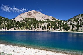
 Lake Helen in Lassen Volcanic National Park | |
| Location | Shasta, Lassen, Plumas, and Tehama counties, California, United States |
| Nearest city | Redding and Susanville |
| Coordinates | 40°29′53″N 121°25′39″W / 40.49806°N 121.42750°W |
| Area | 106,452 acres (430.80 km2)[1] |
| Established | August 9, 1916 |
| Visitors | 499,435 (in 2018)[2] |
| Governing body | National Park Service |
| Website | nps |


Lassen Volcanic National Park is an American national park in northeastern California. The dominant feature of the park is Lassen Peak, the largest plug dome volcano in the world and the southernmost volcano in the Cascade Range.[3] Lassen Volcanic National Park is one of the few areas in the world where all four types of volcanoes can be found: plug dome, shield, cinder cone, and stratovolcano.[4]
The source of heat for the volcanism in the Lassen area is subduction of the Gorda Plate diving below the North American Plate off the Northern California coast.[5] The area surrounding Lassen Peak is still active with boiling mud pots, fumaroles, and hot springs.[6]
Lassen Volcanic National Park started as two separate national monuments designated by President Theodore Roosevelt in 1907: Cinder Cone National Monument and Lassen Peak National Monument.[7] Starting in May 1914 and lasting until 1917, a series of minor to major eruptions occurred on Lassen. Because of the eruptive activity and the area's stark volcanic beauty, Lassen Peak, Cinder Cone, and the area surrounding were established as a National Park on August 9, 1916.[8]
- ^ "Listing of acreage – December 31, 2011" (XLSX). Land Resource Division, National Park Service. Retrieved March 7, 2012. (National Park Service Acreage Reports)
- ^ "NPS Annual Recreation Visits Report". National Park Service. Retrieved March 8, 2019.
- ^ Topinka, Topink (May 11, 2005). "Lassen Peak Volcano, California". United States Geological Survey. Archived from the original on April 4, 2012. Retrieved March 11, 2012.
- ^ "HOTSPOT: California On The Edge: Cascade Range Volcanoes". California Academy of Sciencies. Archived from the original on March 6, 2012. Retrieved March 11, 2012.
- ^ Lynch, David K. "Volcanoes and their relationship to plate tectonics". SanAndreasFault.org. Archived from the original on March 20, 2012. Retrieved March 11, 2012.
- ^ Clynne, Michael A; Janik, Cathy J; Muffler, LJP. "Hot Water in Lassen Volcanic National Park: Fumaroles, Steaming Ground, and Boiling Mudpots" (PDF). United States Geological Survey. Archived (PDF) from the original on January 30, 2012. Retrieved March 11, 2012.
- ^ Lee, Robert F (2001). "The Story of the Antiquities Act". Archived from the original on October 26, 2012. Retrieved March 11, 2012. Chapter 8: The Proclamation of National Monuments Under the Antiquities Act, 1906–1970
- ^ Cite error: The named reference
GeologyNP466was invoked but never defined (see the help page).
© MMXXIII Rich X Search. We shall prevail. All rights reserved. Rich X Search

