Back Le Bec-Hellouin AST Le Bec Hellouin BUG Le Bec-Hellouin Catalan Ле-Бек-Еллуен CE Le Bec-Hellouin CEB Le Bec-Hellouin German Λε Μπεκ-Ελουέν Greek Le Bec-Hellouin Spanish Le Bec-Hellouin Basque Le Bec-Hellouin Finnish
Le Bec-Hellouin | |
|---|---|
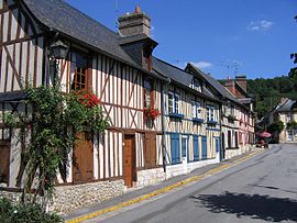
 Houses in Le Bec-Hellouin | |
| Coordinates: 49°13′57″N 0°43′18″E / 49.2325°N 0.7217°E | |
| Country | France |
| Region | Normandy |
| Department | Eure |
| Arrondissement | Bernay |
| Canton | Brionne |
| Intercommunality | Bernay Terres de Normandie |
| Government | |
| • Mayor (2020–2026) | Pascal Finet[1] |
| Area 1 | 9.55 km2 (3.69 sq mi) |
| Population (2021)[2] | 390 |
| • Density | 41/km2 (110/sq mi) |
| Time zone | UTC+01:00 (CET) |
| • Summer (DST) | UTC+02:00 (CEST) |
| INSEE/Postal code | 27052 /27800 |
| Elevation | 46–141 m (151–463 ft) |
| 1 French Land Register data, which excludes lakes, ponds, glaciers > 1 km2 (0.386 sq mi or 247 acres) and river estuaries. | |
Le Bec-Hellouin (French pronunciation: [lə bɛk ɛlwɛ̃]) is a commune in the department of Eure in the Normandy region in northern France.
It is best known for Bec Abbey and has recently been voted one of the "most beautiful villages of France". The current mayor is Pascal Finet who replaced Jean-Paul Vittecoq in 2014.
- ^ "Répertoire national des élus: les maires" (in French). data.gouv.fr, Plateforme ouverte des données publiques françaises. 13 September 2022.
- ^ "Populations légales 2021" (in French). The National Institute of Statistics and Economic Studies. 28 December 2023.
© MMXXIII Rich X Search. We shall prevail. All rights reserved. Rich X Search


