Back لو تشيسناي Arabic لو شسنيه ARZ لو شزنه AZB Le Chesnay Breton Le Chesnay BUG Le Chesnay Catalan Ле-Шене CE Le Chesnay CEB Le Chesnay Czech Le Chesnay German
Le Chesnay | |
|---|---|
Part of Le Chesnay-Rocquencourt | |
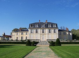
 Château Aubert | |
 Location (in red) within Paris inner and outer suburbs | |
| Coordinates: 48°49′16″N 2°07′52″E / 48.8211°N 2.1311°E | |
| Country | France |
| Region | Île-de-France |
| Department | Yvelines |
| Arrondissement | Versailles |
| Canton | Le Chesnay-Rocquencourt |
| Commune | Le Chesnay-Rocquencourt |
| Area 1 | 4.24 km2 (1.64 sq mi) |
| Population (2019)[1] | 27,620 |
| • Density | 6,500/km2 (17,000/sq mi) |
| Time zone | UTC+01:00 (CET) |
| • Summer (DST) | UTC+02:00 (CEST) |
| Postal code | 78150 |
| Elevation | 113–175 m (371–574 ft) (avg. 145 m or 476 ft) |
| 1 French Land Register data, which excludes lakes, ponds, glaciers > 1 km2 (0.386 sq mi or 247 acres) and river estuaries. | |
Le Chesnay (French pronunciation: [lə ʃɛnɛ] ) is a former commune in the Yvelines department in the Île-de-France region in north-central France. On 1 January 2019, it was merged into the new commune Le Chesnay-Rocquencourt.[2] It is located in the western suburbs of Paris, 16.7 km (10.4 mi) from the center of Paris.
- ^ Téléchargement du fichier d'ensemble des populations légales en 2019, INSEE
- ^ Arrêté préfectoral 29 November 2018 (in French)
© MMXXIII Rich X Search. We shall prevail. All rights reserved. Rich X Search


