Back Malcolm X Boulevard (Harlem) Spanish Malcolm X Boulevard French Malcolm X Boulevard SCO Ленокс-авеню Ukrainian
| Malcolm X Boulevard | |
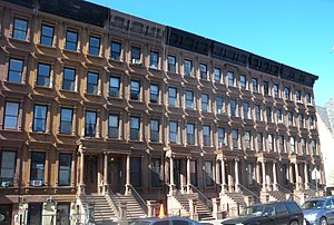
 Row houses on Lenox Avenue between 122nd and 123rd Streets are part of the Mount Morris Park Historic District | |
 | |
| Former name(s) | Sixth Avenue |
|---|---|
| Part of | Sixth Avenue |
| Namesake | James Lenox and Malcolm X |
| Owner | City of New York |
| Maintained by | NYCDOT |
| Length | 1.9 mi (3.1 km)[1] |
| Location | Manhattan, New York City |
| South end | Central Park North / East Drive in Harlem |
| Major junctions | 145th Street Bridge in Harlem |
| North end | 147th Street in Harlem |
| East | Fifth Avenue |
| West | Adam Clayton Powell Jr. Boulevard |
| Construction | |
| Commissioned | March 1811 |
Lenox Avenue – also named Malcolm X Boulevard; both names are officially recognized – is the primary north–south route through Harlem in the upper portion of the New York City borough of Manhattan. This two-way street runs from Farmers' Gate at Central Park North (110th Street) to 147th Street. Its traffic is figuratively described as "Harlem's heartbeat" by Langston Hughes in his poem Juke Box Love Song.[2] The IRT Lenox Avenue Line runs under the entire length of the street, serving the New York City Subway's 2 and 3 trains.
From 119th Street to 123rd Street, Lenox Avenue is part of the Mount Morris Park Historic District, designated by the New York City Landmarks Preservation Commission in 1971.[3]
- ^ Google (September 13, 2015). "Lenox Avenue / Malcolm X Boulevard" (Map). Google Maps. Google. Retrieved September 13, 2015.
- ^ "Governor Announces $11 Million to Enhance NYC Communities (Bronx, Brooklyn, Kings, New York & Queens Counties)" (Press release). New York State Department of Transportation. April 6, 2000. Retrieved May 25, 2007.
- ^ New York City Landmarks Preservation Commission; Dolkart, Andrew S.; Postal, Matthew A. (2009). Postal, Matthew A. (ed.). Guide to New York City Landmarks (4th ed.). New York: John Wiley & Sons. ISBN 978-0-470-28963-1., p.205
© MMXXIII Rich X Search. We shall prevail. All rights reserved. Rich X Search