Back Leticia Afrikaans ليتيسيا (أمازوناس) Arabic Leticia (Kuluwya) Aymara Letisiya Azerbaijani Leticia (Amazones) Catalan Leticia (munisipyo) CEB Leticia Czech Leticia Danish Leticia German Leticia Esperanto
This article needs additional citations for verification. (March 2014) |
Leticia | |
|---|---|
Municipality and town | |
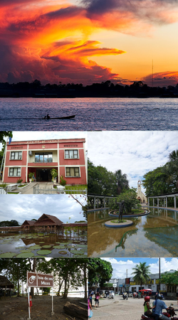
 (Clockwise from the top):
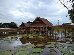
Sunset in the Amazonas River, Santander Park with the Cathedral of Leticia in the background, downtown Leticia (near the border between Colombia and Brazil), Los Micos River Island, Victoria Regia lotus garden, Leticia City Hall (Alcaldía de Leticia) | |
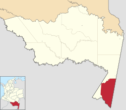
 Location map of the municipality and town of Leticia in the Department of Amazonas. | |
| Coordinates: 4°12′19″S 69°55′58″W / 4.20528°S 69.93278°W | |
| Country | |
| Department | |
| Foundation | 1867 |
| Government | |
| • Mayor | Jorge Luis Mendoza |
| Area | |
| • Municipality and town | 6,182 km2 (2,387 sq mi) |
| • Urban | 13.05 km2 (5.04 sq mi) |
| Elevation | 96 m (315 ft) |
| Population | |
| • Municipality and town | 48,144 |
| • Density | 7.8/km2 (20/sq mi) |
| • Urban | 33,503 |
| • Urban density | 2,600/km2 (6,600/sq mi) |
| Demonym | Leticiano |
| Time zone | UTC-5 |
| Area code | 57 + 8 |
| Climate | Af |
| Website | Official website |
Leticia (Spanish pronunciation: [leˈtisja]) is the southernmost city in the Republic of Colombia, capital of the department of Amazonas, Colombia's southernmost town (4.09° south 69.57° west) and one of the major ports on the Amazon River. It has an elevation of 96 meters (315') above sea level and an average temperature of 27 °C (80.6 °F). Leticia has long been Colombia's shipping point for tropical fish for the aquarium trade. Leticia has a population of 33,503 located on the left bank of the Amazon River at the point where the borders of Colombia, Brazil and Peru meet in an area called Tres Fronteras.

A long-standing border dispute involving Leticia, between Colombia and Peru, was decided in 1934 by the League of Nations after these two nations were engulfed in an armed conflict known as the Colombia-Peru War.[3]
- ^ "Información capital" (PDF). www.dane.gov.co (in Spanish). Departamento Administrativo Nacional de Estadística (DANE). p. 74.
- ^ Citypopulation.de Population of Leticia municipality with localities
- ^ Stahn, Carsten (2008). The Law and Practice of International Territorial Administration. doi:10.1017/CBO9780511585937. ISBN 978-0-521-87800-5.
© MMXXIII Rich X Search. We shall prevail. All rights reserved. Rich X Search


