Back ليكسينغتون (مسيسيبي) Arabic ليكسينجتون (هولمز) ARZ لکزینقتن، میسیسیپی AZB Lexington (Mississipi) Catalan Лексингтон (Миссисипи) CE Lexington (kapital sa kondado sa Tinipong Bansa, Mississippi) CEB Lexington, Mississippi Welsh Lexington (Mississippi) German Lexington (Misisipi) Spanish Lexington (Mississippi) Basque
Lexington, Mississippi | |
|---|---|
 St. Mary's Episcopal Church | |
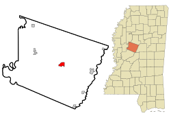
 Location of Lexington, Mississippi | |
| Coordinates: 33°6′52″N 90°3′4″W / 33.11444°N 90.05111°W | |
| Country | United States |
| State | Mississippi |
| County | Holmes |
| Government | |
| • Mayor | Robin McCrory |
| Area | |
| • Total | 2.42 sq mi (6.27 km2) |
| • Land | 2.42 sq mi (6.26 km2) |
| • Water | 0.00 sq mi (0.01 km2) |
| Elevation | 233 ft (71 m) |
| Population (2020) | |
| • Total | 1,602 |
| • Density | 662.81/sq mi (255.86/km2) |
| Time zone | UTC-6 (Central (CST)) |
| • Summer (DST) | UTC-5 (CDT) |
| ZIP code | 39095 |
| Area code | 662 |
| FIPS code | 28-40600 |
| GNIS feature ID | 0672434 |
Lexington is a city in and the county seat of Holmes County, Mississippi, United States. The county was organized in 1833 and the city in 1836. The population was 1,731 at the 2010 census,[2] down from 2,025 at the 2000 census. The estimated population in 2018 was 1,496.[3] It has declined from its high of 3,198 in 1950 due to the expansion of industrial-scale agriculture.
- ^ "2020 U.S. Gazetteer Files". United States Census Bureau. Retrieved July 24, 2022.
- ^ "Geographic Identifiers: 2010 Census Summary File 1 (G001): Lexington city, Mississippi". American Factfinder. U.S. Census Bureau. Archived from the original on February 13, 2020. Retrieved August 17, 2017.
- ^ "Population and Housing Unit Estimates". Retrieved January 5, 2020.
© MMXXIII Rich X Search. We shall prevail. All rights reserved. Rich X Search

