Back Rotse van Liancourt Afrikaans صخور ليانكورت Arabic Liankur Azerbaijani Liankūra salas BAT-SMG Roques de Liancourt Catalan Reef sa Liancourt CEB Tokdo Czech Liancourt-øerne Danish Liancourt-Felsen German Liancourt-Rokoj Esperanto
| Disputed islands | |
|---|---|
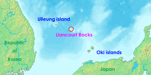
 Location of the Liancourt Rocks in the Sea of Japan between Japan and South Korea | |
 | |
| Other names | Liancourt Islets, Liancourt Islands, Takeshima, Dokdo, Tok Islets, Hornet Islands, Kajido, Sambongdo |
| Geography | |
| Location | Sea of Japan |
| Coordinates | 37°14′30″N 131°52′0″E / 37.24167°N 131.86667°E |
| Total islands | 91 (37 permanent land) |
| Major islands | East Islet, West Islet |
| Area | 18.745 ha (46.32 acres) East Islet: 7.33 hectares (18.1 acres) West Islet: 8.864 hectares (21.90 acres) |
| Highest elevation | 169 m (554 ft) |
| Highest point | West Islet |
| Administration | |
| County | Ulleung County, North Gyeongsang |
| Claimed by | |
| Town | Okinoshima, Shimane (Japan) |
| County | Ulleung County, North Gyeongsang |
| Demographics | |
| Population | Approximately 34[1] |
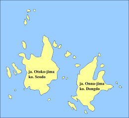
The Liancourt Rocks,[2] also known by their Korean name of Dokdo[a] or their Japanese name of Takeshima,[b] are a group of islets in the Sea of Japan between the Korean peninsula and the Japanese archipelago administered by South Korea. The Liancourt Rocks comprise two main islets and 35 smaller rocks; the total surface area of the islets is 0.187554 square kilometres (46.346 acres) and the highest elevation of 168.5 metres (553 ft) is on the West Islet.[4][dead link] The Liancourt Rocks lie in rich fishing grounds that may contain large deposits of natural gas.[5] The English name Liancourt Rocks is derived from Le Liancourt,[c] the name of a French whaling ship that came close to being wrecked on the rocks in 1849.[6]
While South Korea controls the islets, its sovereignty over them is contested by Japan. North Korea also claims the territory. South Korea classifies the islets as Dokdo-ri, Ulleung-eup, Ulleung County, North Gyeongsang Province,[7] while Japan classifies the islands as part of Okinoshima, Oki District, Shimane Prefecture.
- ^ "Dokdo Residents". Gyeongsangbuk-do Province. Retrieved 17 February 2021.
- ^ Fern 2005, p. 78: "Since the end of World War II, Japan and Korea have contested ownership of these islets, given the name Liancourt Rocks by French whalers in the mid-1800s and called that by neutral observers to this day".
- ^ BBC staff 2006.
- ^ Gyeongsangbuk-do Province 2017b.
- ^ BBC staff 2008.
- ^ Kirk 2008.
- ^ 울릉군리의명칭과구역에관한조례 [개정 2000. 4. 7 조례 제1395호] [Act 1395 amending Chapter 14-2, Ri-Administration under Ulleung County, Local Autonomy Law, Ulleung County] (in Korean). "2000년 4월 7일 울릉군조례 제1395호로 독도리가 신설됨에 따라 독도의 행정구역이 종전의 경상북도 울릉군 울릉읍 도동리 산42~76번지에서 경상북도 울릉군 울릉읍 독도리 산1~37번지로 변경 됨."
Translation: "Pursuant to Act 1395 amending Chapter 14-2, Ri-Administration under Ulleung County, Local Autonomy Law, Ulleung County, passed March 20, 2000, enacted April 7, 2000, the administrative designation of Dokdo addresses as 42 to 76, Dodong-ri, Ulleung-eup, Ulleung County, North Gyungsang Province, is changed to address 1 to 37, Dokdo-ri, Ulleung-eup, Ulleung County, North Gyungsang Province." 조회 (in Korean). Archived from the original on 1 March 2009. Retrieved 12 September 2008.
Cite error: There are <ref group=lower-alpha> tags or {{efn}} templates on this page, but the references will not show without a {{reflist|group=lower-alpha}} template or {{notelist}} template (see the help page).
© MMXXIII Rich X Search. We shall prevail. All rights reserved. Rich X Search