Back ليبرتي (كارولاينا الجنوبية) Arabic ليبرتى (بيكنز) ARZ لیبرتی، گونئی کارولینا AZB Liberty (Carolina del Sud) Catalan Либерти (Къилба Каролина) CE Liberty (lungsod sa Tinipong Bansa, South Carolina) CEB Liberty, De Carolina Welsh Liberty (Carolina del Sur) Spanish Liberty (Hego Carolina) Basque لیبرتی، کارولینای جنوبی Persian
Liberty, South Carolina | |
|---|---|
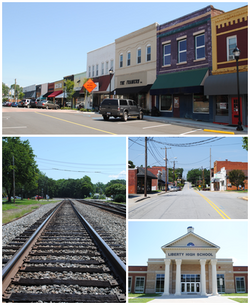
 Top, left to right: Downtown Liberty, railroad tracks, West Front Street, Liberty High School | |
 Location of Liberty, South Carolina | |
| Coordinates: 34°47′18″N 82°41′42″W / 34.78833°N 82.69500°W | |
| Country | United States |
| State | South Carolina |
| County | Pickens |
| Government | |
| • Type | Mayor–council government |
| • Body | Liberty City Council |
| • Mayor | Erica Romo Woods |
| • City Council | List
|
| Area | |
| • Total | 4.54 sq mi (11.76 km2) |
| • Land | 4.53 sq mi (11.73 km2) |
| • Water | 0.01 sq mi (0.03 km2) |
| Elevation | 984 ft (300 m) |
| Population | |
| • Total | 3,366 |
| • Density | 743.54/sq mi (287.08/km2) |
| Time zone | UTC−5 (Eastern (EST)) |
| • Summer (DST) | UTC−4 (EDT) |
| ZIP code | 29657 |
| Area code | 864 |
| FIPS code | 45-41380[4] |
| GNIS feature ID | 1246350[2] |
| Website | www.libertysc.com |
Liberty is a city in Pickens County, South Carolina, United States. It is part of the Greenville–Mauldin–Easley Metropolitan Statistical Area. The city was chartered on March 2, 1876.
- ^ "ArcGIS REST Services Directory". United States Census Bureau. Retrieved October 15, 2022.
- ^ a b U.S. Geological Survey Geographic Names Information System: Liberty, South Carolina
- ^ Cite error: The named reference
USCensusDecennial2020CenPopScriptOnlywas invoked but never defined (see the help page). - ^ "U.S. Census website". United States Census Bureau. Retrieved January 31, 2008.
© MMXXIII Rich X Search. We shall prevail. All rights reserved. Rich X Search

